Pendleton geodata
Pendleton (Indiana) is a populated place; located in United States in America/Indiana/Indianapolis (GMT-4) time zone. With population of 4,219 people, there are 7954 cities with bigger population in this country. Compared to other cities in United States, 53.6% of cities are located further ↓South; 53.6% of cities are located further ←West and 64.1% of cities have lower elevation than Pendleton. Note1
Administrative division(s):
- Level 1: Indiana
- Level 2: Madison County
- Level 3: Township of Fall Creek


Pendleton GPS coordinates[2]
39° 59' 51.144" North, 85° 44' 47.904" West
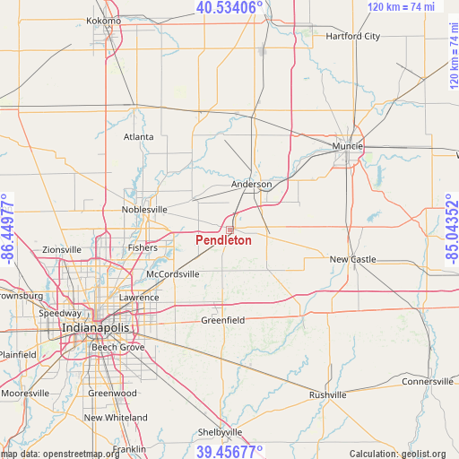
| Map corner | latitude | longitude |
|---|---|---|
| Upper-left | 40.53406°, | -86.44977° |
| Center: | 39.99754°, | -85.74664° |
| Lower-right: | 39.45677°, | -85.04352° |
| Map W x H: | 119.8×119.8 km | = 74.4×74.4mi |
| max Lat: | 71.29058° ⇑46.4% North |
| Pendleton: | 39.99754° |
| min Lat: | ⇓53.6% South 19.06759° |
| min Long | Pendleton | max Long |
| -171.73463° | -85.74664° | -66.98998° |
| W 53.6%⇐ | ⇒46.4% E |
Elevation
Elevation of Pendleton is 258 m = 846 ft, and this is 36.8 m = 121 ft below average elevation for this country.
| Max E: |
3189 m = 10463 ft | 35.9% |
| Avg. | 294.8 m = 967 ft | |
| Pendleton | 258 m = 846 ft | |
Min E: |
-60 m = -197 ft | 64.1% |
See also: United States elevation on elevation.city.
Geographical zone
Pendleton is located in North temperate zone (between Tropic of Cancer and the Arctic Circle). Distance of this Northern Tropic circle is 1841.4 km =1144.2 mi to South.| Distance of | km | miles | from Pendleton |
|---|---|---|---|
| North Pole | 5559.8 | 3454.7 | to North |
| Arctic Circle | 2953.9 | 1835.5 | to North |
| Tropic Cancer | 1841.4 | 1144.2 | to South |
| Equator | 4447.3 | 2763.4 | to South |


Nearby cities:
15 places around Pendleton: (largest is in red/bold)
• Anderson
13.2 km =8.2 mi,  25°
25°
• Chesterfield
18.1 km =11.2 mi,  44°
44°
• Daleville
21.1 km =13.1 mi,  49°
49°
• Edgewood
11.8 km =7.3 mi,  5°
5°
• Fishers
23.2 km =14.4 mi,  258°
258°
• Fortville
11.3 km =7 mi,  229°
229°
• Frankton
25.2 km =15.7 mi,  353°
353°
• Greenfield
23.7 km =14.7 mi,  184°
184°
• Ingalls
6.7 km =4.2 mi, 227°
• Lapel
11.7 km =7.3 mi,  312°
312°
• Markleville
11.5 km =7.1 mi,  101°
101°
• McCordsville
18 km =11.2 mi,  236°
236°
• Middletown
19 km =11.8 mi,  69°
69°
• Noblesville
22.9 km =14.2 mi,  283°
283°
• Shirley
18.6 km =11.6 mi,  129°
129°
Sources, notices
• [Note1] Compared only with cities in United States existing in our database
• [Src1] Map data: © OpenStreetMap contributors (CC-BY-SA)
• [Src2] Other city data from geonames.org with taken over terms of usage.
• [Src3] Geographical zone / Annual Mean Temperature by Robert A. Rohde @ Wikipedia
