New Palestine geodata
New Palestine (Indiana) is a populated place; located in United States in America/Indiana/Indianapolis (GMT-4) time zone. With population of 2,221 people, there are 11292 cities with bigger population in this country. Compared to other cities in United States, 50.8% of cities are located further ↓South; 53.2% of cities are located further ←West and 64.1% of cities have lower elevation than New Palestine. Note1
Administrative division(s):
- Level 1: Indiana
- Level 2: Hancock County
- Level 3: Township of Sugar Creek


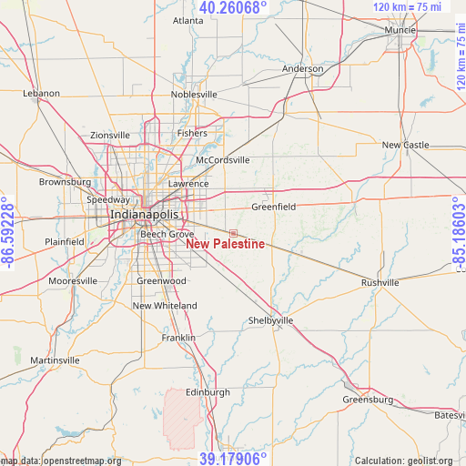
New Palestine GPS coordinates[2]
39° 43' 19.164" North, 85° 53' 20.94" West
| Map corner | latitude | longitude |
|---|---|---|
| Upper-left | 40.26068°, | -86.59228° |
| Center: | 39.72199°, | -85.88915° |
| Lower-right: | 39.17906°, | -85.18603° |
| Map W x H: | 120.3×120.3 km | = 74.8×74.8mi |
| max Lat: | 71.29058° ⇑49.2% North |
| New Palestine: | 39.72199° |
| min Lat: | ⇓50.8% South 19.06759° |
| min Long | New Palestine | max Long |
| -171.73463° | -85.88915° | -66.98998° |
| W 53.2%⇐ | ⇒46.8% E |
Elevation
Elevation of New Palestine is 258 m = 846 ft, and this is 36.8 m = 121 ft below average elevation for this country.
| Max E: |
3189 m = 10463 ft | 35.9% |
| Avg. | 294.8 m = 967 ft | |
| New Palestine | 258 m = 846 ft | |
Min E: |
-60 m = -197 ft | 64.1% |
See also: United States elevation on elevation.city.
Geographical zone
New Palestine is located in North temperate zone (between Tropic of Cancer and the Arctic Circle). Distance of this Northern Tropic circle is 1810.8 km =1125.2 mi to South.| Distance of | km | miles | from New Palestine |
|---|---|---|---|
| North Pole | 5590.4 | 3473.7 | to North |
| Arctic Circle | 2984.5 | 1854.5 | to North |
| Tropic Cancer | 1810.8 | 1125.2 | to South |
| Equator | 4416.7 | 2744.4 | to South |


Nearby cities:
15 places around New Palestine: (largest is in red/bold)
• Beech Grove
17.2 km =10.7 mi,  270°
270°
• Cumberland
8.4 km =5.2 mi,  315°
315°
• Fairland
15.3 km =9.5 mi,  171°
171°
• Fortville
23.6 km =14.7 mi,  8°
8°
• Greenfield
12.4 km =7.7 mi,  55°
55°
• Greenwood
22.2 km =13.8 mi,  237°
237°
• Homecroft
21.5 km =13.4 mi,  254°
254°
• Indianapolis
23.6 km =14.7 mi,  282°
282°
• Lawrence
17.4 km =10.8 mi, 318°
• McCordsville
20.9 km =13 mi,  352°
352°
• Morristown
17.2 km =10.7 mi,  108°
108°
• Shelbyville
24.3 km =15.1 mi,  156°
156°
• Southport
21.4 km =13.3 mi, 252°
• Warren Park
15.3 km =9.5 mi,  295°
295°
• Whiteland
25.1 km =15.6 mi,  220°
220°
Sources, notices
• [Note1] Compared only with cities in United States existing in our database
• [Src1] Map data: © OpenStreetMap contributors (CC-BY-SA)
• [Src2] Other city data from geonames.org with taken over terms of usage.
• [Src3] Geographical zone / Annual Mean Temperature by Robert A. Rohde @ Wikipedia
