Harrodsburg geodata
Harrodsburg (Indiana) is a populated place; located in United States in America/Indiana/Indianapolis (GMT-4) time zone. With population of 691 people, there are 18770 cities with bigger population in this country. Compared to other cities in United States, 54.7% of cities are located further ↑North; 51.4% of cities are located further ←West and 55.3% of cities have higher elevation than Harrodsburg. Note1
Administrative division(s):
- Level 1: Indiana
- Level 2: Monroe County
- Level 3: Township of Clear Creek


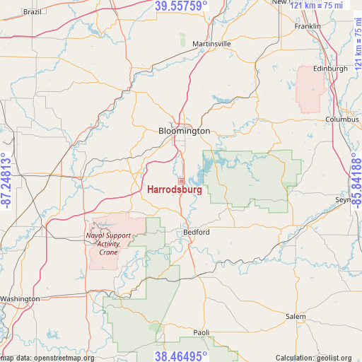
Harrodsburg GPS coordinates[2]
39° 0' 48.168" North, 86° 32' 42" West
| Map corner | latitude | longitude |
|---|---|---|
| Upper-left | 39.55759°, | -87.24813° |
| Center: | 39.01338°, | -86.545° |
| Lower-right: | 38.46495°, | -85.84188° |
| Map W x H: | 121.5×121.5 km | = 75.5×75.5mi |
| max Lat: | 71.29058° ⇑54.7% North |
| Harrodsburg: | 39.01338° |
| min Lat: | ⇓45.3% South 19.06759° |
| min Long | Harrodsburg | max Long |
| -171.73463° | -86.545° | -66.98998° |
| W 51.4%⇐ | ⇒48.6% E |
Elevation
Elevation of Harrodsburg is 179 m = 587 ft, and this is 115.8 m = 380 ft below average elevation for this country.
| Max E: |
3189 m = 10463 ft | 55.3% |
| Avg. | 294.8 m = 967 ft | |
| Harrodsburg | 179 m = 587 ft | |
Min E: |
-60 m = -197 ft | 44.7% |
See also: United States elevation on elevation.city.
Geographical zone
Harrodsburg is located in North temperate zone (between Tropic of Cancer and the Arctic Circle). Distance of this Northern Tropic circle is 1732 km =1076.2 mi to South.| Distance of | km | miles | from Harrodsburg |
|---|---|---|---|
| North Pole | 5669.2 | 3522.7 | to North |
| Arctic Circle | 3063.3 | 1903.4 | to North |
| Tropic Cancer | 1732 | 1076.2 | to South |
| Equator | 4337.9 | 2695.4 | to South |


Nearby cities:
15 places around Harrodsburg: (largest is in red/bold)
• Avoca
11.3 km =7 mi,  181°
181°
• Bedford
17.6 km =10.9 mi,  163°
163°
• Bloomfield
33.9 km =21.1 mi,  272°
272°
• Bloomington
17 km =10.6 mi,  5°
5°
• Ellettsville
25.5 km =15.8 mi,  344°
344°
• Gosport
39 km =24.2 mi, 344°
• Medora
38.6 km =24 mi,  122°
122°
• Mitchell
31.8 km =19.8 mi,  168°
168°
• Nashville
33.3 km =20.7 mi,  49°
49°
• Oolitic
12.6 km =7.8 mi, 172°
• Orleans
39.9 km =24.8 mi, 168°
• Paragon
42.5 km =26.4 mi,  357°
357°
• Smithville-Sanders
5.9 km =3.7 mi,  29°
29°
• Spencer
35.7 km =22.2 mi,  328°
328°
• Worthington
39.5 km =24.5 mi,  288°
288°
Sources, notices
• [Note1] Compared only with cities in United States existing in our database
• [Src1] Map data: © OpenStreetMap contributors (CC-BY-SA)
• [Src2] Other city data from geonames.org with taken over terms of usage.
• [Src3] Geographical zone / Annual Mean Temperature by Robert A. Rohde @ Wikipedia
