Bedford geodata
Bedford (Indiana) is a seat of a second-order administrative division; located in United States in America/Indiana/Indianapolis (GMT-4) time zone. With population of 13,347 people, there are 3584 cities with bigger population in this country. Compared to other cities in United States, 56.1% of cities are located further ↑North; 51.6% of cities are located further ←West and 53.2% of cities have lower elevation than Bedford. Note1
Administrative division(s):
- Level 1: Indiana
- Level 2: Lawrence County
- Level 3: Township of Shawswick


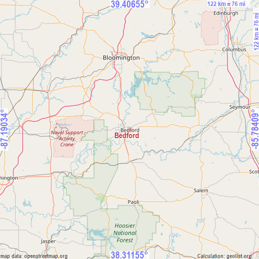
Bedford GPS coordinates[2]
38° 51' 40.176" North, 86° 29' 13.956" West
| Map corner | latitude | longitude |
|---|---|---|
| Upper-left | 39.40655°, | -87.19034° |
| Center: | 38.86116°, | -86.48721° |
| Lower-right: | 38.31155°, | -85.78409° |
| Map W x H: | 121.8×121.8 km | = 75.7×75.7mi |
| max Lat: | 71.29058° ⇑56.1% North |
| Bedford: | 38.86116° |
| min Lat: | ⇓43.9% South 19.06759° |
| min Long | Bedford | max Long |
| -171.73463° | -86.48721° | -66.98998° |
| W 51.6%⇐ | ⇒48.4% E |
Elevation
Elevation of Bedford is 211 m = 692 ft, and this is 83.8 m = 275 ft below average elevation for this country.
| Max E: |
3189 m = 10463 ft | 46.8% |
| Avg. | 294.8 m = 967 ft | |
| Bedford | 211 m = 692 ft | |
Min E: |
-60 m = -197 ft | 53.2% |
See also: United States elevation on elevation.city.
Geographical zone
Bedford is located in North temperate zone (between Tropic of Cancer and the Arctic Circle). Distance of this Northern Tropic circle is 1715 km =1065.7 mi to South.| Distance of | km | miles | from Bedford |
|---|---|---|---|
| North Pole | 5686.1 | 3533.2 | to North |
| Arctic Circle | 3080.2 | 1913.9 | to North |
| Tropic Cancer | 1715 | 1065.7 | to South |
| Equator | 4321 | 2684.9 | to South |


Nearby cities:
15 places around Bedford: (largest is in red/bold)
• Avoca
7.7 km =4.8 mi,  317°
317°
• Bloomington
34 km =21.1 mi,  354°
354°
• Brownstown
38.6 km =24 mi,  87°
87°
• Campbellsburg
30.5 km =19 mi,  139°
139°
• French Lick
36.6 km =22.7 mi,  198°
198°
• Harrodsburg
17.6 km =10.9 mi,  343°
343°
• Loogootee
42.3 km =26.3 mi,  241°
241°
• Medora
27.8 km =17.3 mi,  98°
98°
• Mitchell
14.3 km =8.9 mi,  175°
175°
• Oolitic
5.5 km =3.4 mi, 323°
• Orleans
22.4 km =13.9 mi,  172°
172°
• Paoli
34 km =21.1 mi, 177°
• Shoals
34.1 km =21.2 mi,  230°
230°
• Smithville-Sanders
22.2 km =13.8 mi, 354°
• West Baden Springs
34.6 km =21.5 mi, 198°
Sources, notices
• [Note1] Compared only with cities in United States existing in our database
• [Src1] Map data: © OpenStreetMap contributors (CC-BY-SA)
• [Src2] Other city data from geonames.org with taken over terms of usage.
• [Src3] Geographical zone / Annual Mean Temperature by Robert A. Rohde @ Wikipedia
