Kirklin geodata
Kirklin (Indiana) is a populated place; located in United States in America/Indiana/Indianapolis (GMT-4) time zone. With population of 776 people, there are 18014 cities with bigger population in this country. Compared to other cities in United States, 55.5% of cities are located further ↓South; 51.9% of cities are located further ←West and 69.5% of cities have lower elevation than Kirklin. Note1


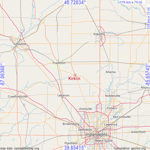
Kirklin GPS coordinates[2]
40° 11' 36.132" North, 86° 21' 37.98" West
| Map corner | latitude | longitude |
|---|---|---|
| Upper-left | 40.72834°, | -87.06368° |
| Center: | 40.19337°, | -86.36055° |
| Lower-right: | 39.65415°, | -85.65743° |
| Map W x H: | 119.4×119.4 km | = 74.2×74.2mi |
| max Lat: | 71.29058° ⇑44.5% North |
| Kirklin: | 40.19337° |
| min Lat: | ⇓55.5% South 19.06759° |
| min Long | Kirklin | max Long |
| -171.73463° | -86.36055° | -66.98998° |
| W 51.9%⇐ | ⇒48.1% E |
Elevation
Elevation of Kirklin is 283 m = 928 ft, and this is 11.8 m = 39 ft below average elevation for this country.
| Max E: |
3189 m = 10463 ft | 30.5% |
| Avg. | 294.8 m = 967 ft | |
| Kirklin | 283 m = 928 ft | |
Min E: |
-60 m = -197 ft | 69.5% |
See also: United States elevation on elevation.city.
Geographical zone
Kirklin is located in North temperate zone (between Tropic of Cancer and the Arctic Circle). Distance of this Northern Tropic circle is 1863.2 km =1157.7 mi to South.| Distance of | km | miles | from Kirklin |
|---|---|---|---|
| North Pole | 5538 | 3441.2 | to North |
| Arctic Circle | 2932.1 | 1821.9 | to North |
| Tropic Cancer | 1863.2 | 1157.7 | to South |
| Equator | 4469.1 | 2777 | to South |


Nearby cities:
15 places around Kirklin: (largest is in red/bold)
• Arcadia
28.9 km =18 mi,  93°
93°
• Atlanta
28.5 km =17.7 mi, 85°
• Cicero
30.5 km =19 mi,  104°
104°
• Colfax
26 km =16.2 mi,  270°
270°
• Dale
19.9 km =12.4 mi,  189°
189°
• Frankfort
16 km =9.9 mi,  306°
306°
• Lebanon
18.6 km =11.6 mi,  209°
209°
• Mulberry
30.8 km =19.1 mi,  303°
303°
• Russiaville
26 km =16.2 mi,  16°
16°
• Sheridan
13.5 km =8.4 mi,  118°
118°
• Thorntown
22.1 km =13.7 mi,  251°
251°
• Tipton
28.9 km =18 mi,  69°
69°
• Westfield
25.9 km =16.1 mi,  130°
130°
• Whitestown
21.8 km =13.5 mi,  176°
176°
• Zionsville
28.2 km =17.5 mi,  162°
162°
Sources, notices
• [Note1] Compared only with cities in United States existing in our database
• [Src1] Map data: © OpenStreetMap contributors (CC-BY-SA)
• [Src2] Other city data from geonames.org with taken over terms of usage.
• [Src3] Geographical zone / Annual Mean Temperature by Robert A. Rohde @ Wikipedia
