Arma geodata
Arma (Kansas) is a populated place; located in United States in America/Chicago (GMT-5) time zone. With population of 1,451 people, there are 13872 cities with bigger population in this country. Compared to other cities in United States, 63.9% of cities are located further ↑North; 70.4% of cities are located further →East and 74.7% of cities have lower elevation than Arma. Note1
Administrative division(s):
- Level 1: Kansas
- Level 2: Crawford County
- Level 3: Township of Washington


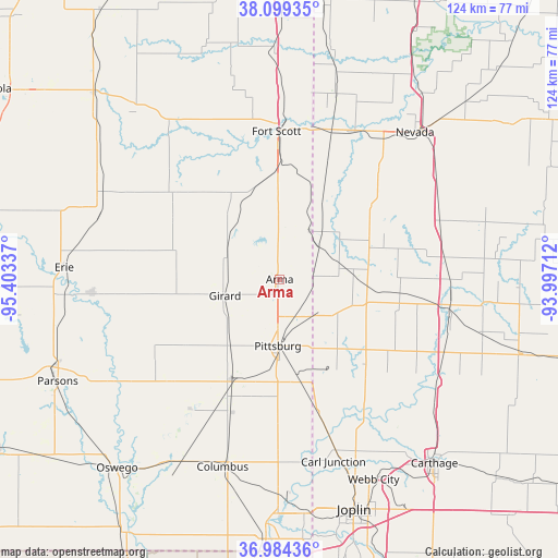
Arma GPS coordinates[2]
37° 32' 38.184" North, 94° 42' 0.864" West
| Map corner | latitude | longitude |
|---|---|---|
| Upper-left | 38.09935°, | -95.40337° |
| Center: | 37.54394°, | -94.70024° |
| Lower-right: | 36.98436°, | -93.99712° |
| Map W x H: | 124×124 km | = 77.1×77.1mi |
| max Lat: | 71.29058° ⇑63.9% North |
| Arma: | 37.54394° |
| min Lat: | ⇓36.1% South 19.06759° |
| min Long | Arma | max Long |
| -171.73463° | -94.70024° | -66.98998° |
| W 29.6%⇐ | ⇒70.4% E |
Elevation
Elevation of Arma is 311 m = 1020 ft, and this is 16.2 m = 53 ft above average elevation for this country.
| Max E: |
3189 m = 10463 ft | 25.3% |
| Arma | 311 m 1020 ft | |
| Avg. | 294.8 m = 967 ft | |
Min E: |
-60 m = -197 ft | 74.7% |
See also: United States elevation on elevation.city.
Geographical zone
Arma is located in North temperate zone (between Tropic of Cancer and the Arctic Circle). Distance of this Northern Tropic circle is 1568.6 km =974.7 mi to South.| Distance of | km | miles | from Arma |
|---|---|---|---|
| North Pole | 5832.6 | 3624.2 | to North |
| Arctic Circle | 3226.7 | 2005 | to North |
| Tropic Cancer | 1568.6 | 974.7 | to South |
| Equator | 4174.5 | 2593.9 | to South |


Nearby cities:
15 places around Arma: (largest is in red/bold)
• Alba
42.2 km =26.2 mi,  143°
143°
• Carl Junction
42.5 km =26.4 mi,  163°
163°
• Cherokee
24 km =14.9 mi,  203°
203°
• Columbus
43.6 km =27.1 mi, 196°
• Fort Scott
32.9 km =20.4 mi,  358°
358°
• Frontenac
9.9 km =6.2 mi,  174°
174°
• Girard
12.7 km =7.9 mi,  253°
253°
• Jasper
42.1 km =26.2 mi,  123°
123°
• Lamar
37.8 km =23.5 mi,  98°
98°
• Liberal
16 km =9.9 mi,  84°
84°
• Mulberry
7.1 km =4.4 mi, 78°
• Pittsburg
14.8 km =9.2 mi,  181°
181°
• Saint Paul
41.8 km =26 mi,  266°
266°
• Sheldon
38.1 km =23.7 mi,  70°
70°
• Weir
26.8 km =16.7 mi,  193°
193°
Sources, notices
• [Note1] Compared only with cities in United States existing in our database
• [Src1] Map data: © OpenStreetMap contributors (CC-BY-SA)
• [Src2] Other city data from geonames.org with taken over terms of usage.
• [Src3] Geographical zone / Annual Mean Temperature by Robert A. Rohde @ Wikipedia
