Cherokee geodata
Cherokee (Kansas) is a populated place; located in United States in America/Chicago (GMT-5) time zone. With population of 713 people, there are 18560 cities with bigger population in this country. Compared to other cities in United States, 64.7% of cities are located further ↑North; 70.6% of cities are located further →East and 70.9% of cities have lower elevation than Cherokee. Note1


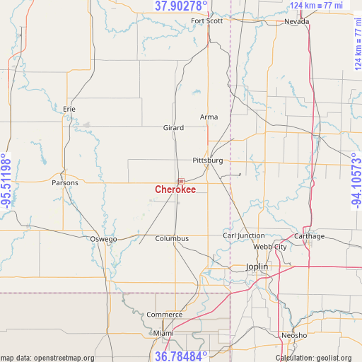
Cherokee GPS coordinates[2]
37° 20' 45.204" North, 94° 48' 31.86" West
| Map corner | latitude | longitude |
|---|---|---|
| Upper-left | 37.90278°, | -95.51198° |
| Center: | 37.34589°, | -94.80885° |
| Lower-right: | 36.78484°, | -94.10573° |
| Map W x H: | 124.3×124.3 km | = 77.2×77.2mi |
| max Lat: | 71.29058° ⇑64.7% North |
| Cherokee: | 37.34589° |
| min Lat: | ⇓35.3% South 19.06759° |
| min Long | Cherokee | max Long |
| -171.73463° | -94.80885° | -66.98998° |
| W 29.4%⇐ | ⇒70.6% E |
Elevation
Elevation of Cherokee is 290 m = 951 ft, and this is 4.8 m = 16 ft below average elevation for this country.
| Max E: |
3189 m = 10463 ft | 29.1% |
| Avg. | 294.8 m = 967 ft | |
| Cherokee | 290 m = 951 ft | |
Min E: |
-60 m = -197 ft | 70.9% |
See also: United States elevation on elevation.city.
Geographical zone
Cherokee is located in North temperate zone (between Tropic of Cancer and the Arctic Circle). Distance of this Northern Tropic circle is 1546.6 km =961 mi to South.| Distance of | km | miles | from Cherokee |
|---|---|---|---|
| North Pole | 5854.6 | 3637.9 | to North |
| Arctic Circle | 3248.7 | 2018.6 | to North |
| Tropic Cancer | 1546.6 | 961 | to South |
| Equator | 4152.5 | 2580.2 | to South |


Nearby cities:
15 places around Cherokee: (largest is in red/bold)
• Airport Drive
34.7 km =21.6 mi,  130°
130°
• Arma
24 km =14.9 mi,  23°
23°
• Baxter Springs
36.4 km =22.6 mi,  169°
169°
• Carl Junction
28.6 km =17.8 mi, 131°
• Columbus
19.9 km =12.4 mi,  189°
189°
• Frontenac
16.1 km =10 mi,  40°
40°
• Galena
33.6 km =20.9 mi,  153°
153°
• Girard
18.6 km =11.6 mi,  352°
352°
• Liberal
34.7 km =21.6 mi,  47°
47°
• Mulberry
28.7 km =17.8 mi, 35°
• Oronogo
34.7 km =21.6 mi,  120°
120°
• Oswego
33.2 km =20.6 mi,  233°
233°
• Pittsburg
11.7 km =7.3 mi, 51°
• Riverton
31.5 km =19.6 mi,  162°
162°
• Weir
5.2 km =3.2 mi,  140°
140°
Sources, notices
• [Note1] Compared only with cities in United States existing in our database
• [Src1] Map data: © OpenStreetMap contributors (CC-BY-SA)
• [Src2] Other city data from geonames.org with taken over terms of usage.
• [Src3] Geographical zone / Annual Mean Temperature by Robert A. Rohde @ Wikipedia
