Mulberry geodata
Mulberry (Kansas) is a populated place; located in United States in America/Chicago (GMT-5) time zone. With population of 507 people, there are 20799 cities with bigger population in this country. Compared to other cities in United States, 63.8% of cities are located further ↑North; 70.2% of cities are located further →East and 68.7% of cities have lower elevation than Mulberry. Note1


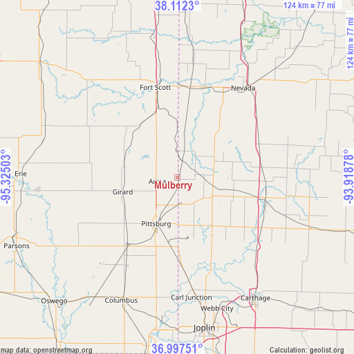
Mulberry GPS coordinates[2]
37° 33' 25.164" North, 94° 37' 18.84" West
| Map corner | latitude | longitude |
|---|---|---|
| Upper-left | 38.1123°, | -95.32503° |
| Center: | 37.55699°, | -94.6219° |
| Lower-right: | 36.99751°, | -93.91878° |
| Map W x H: | 124×124 km | = 77.1×77.1mi |
| max Lat: | 71.29058° ⇑63.8% North |
| Mulberry: | 37.55699° |
| min Lat: | ⇓36.2% South 19.06759° |
| min Long | Mulberry | max Long |
| -171.73463° | -94.6219° | -66.98998° |
| W 29.8%⇐ | ⇒70.2% E |
Elevation
Elevation of Mulberry is 279 m = 915 ft, and this is 15.8 m = 52 ft below average elevation for this country.
| Max E: |
3189 m = 10463 ft | 31.3% |
| Avg. | 294.8 m = 967 ft | |
| Mulberry | 279 m = 915 ft | |
Min E: |
-60 m = -197 ft | 68.7% |
See also: United States elevation on elevation.city.
Geographical zone
Mulberry is located in North temperate zone (between Tropic of Cancer and the Arctic Circle). Distance of this Northern Tropic circle is 1570 km =975.6 mi to South.| Distance of | km | miles | from Mulberry |
|---|---|---|---|
| North Pole | 5831.1 | 3623.3 | to North |
| Arctic Circle | 3225.2 | 2004 | to North |
| Tropic Cancer | 1570 | 975.6 | to South |
| Equator | 4175.9 | 2594.8 | to South |


Nearby cities:
15 places around Mulberry: (largest is in red/bold)
• Alba
39.8 km =24.7 mi,  152°
152°
• Arma
7.1 km =4.4 mi,  258°
258°
• Carl Junction
42.6 km =26.5 mi,  173°
173°
• Cherokee
28.7 km =17.8 mi,  215°
215°
• Fort Scott
32.3 km =20.1 mi,  346°
346°
• Frontenac
12.7 km =7.9 mi,  207°
207°
• Girard
19.7 km =12.2 mi, 255°
• Jasper
37.5 km =23.3 mi,  130°
130°
• Lamar
31.2 km =19.4 mi,  102°
102°
• Liberal
9 km =5.6 mi,  89°
89°
• Nevada
39.2 km =24.4 mi,  36°
36°
• Oronogo
43.1 km =26.8 mi,  161°
161°
• Pittsburg
17.8 km =11.1 mi,  204°
204°
• Sheldon
31.1 km =19.3 mi,  68°
68°
• Weir
30.5 km =19 mi, 205°
Sources, notices
• [Note1] Compared only with cities in United States existing in our database
• [Src1] Map data: © OpenStreetMap contributors (CC-BY-SA)
• [Src2] Other city data from geonames.org with taken over terms of usage.
• [Src3] Geographical zone / Annual Mean Temperature by Robert A. Rohde @ Wikipedia
