Pratt geodata
Pratt (Kansas) is a seat of a second-order administrative division; located in United States in America/Chicago (GMT-5) time zone. With population of 6,849 people, there are 5896 cities with bigger population in this country. Compared to other cities in United States, 63.5% of cities are located further ↑North; 79.7% of cities are located further →East and 89.4% of cities have lower elevation than Pratt. Note1


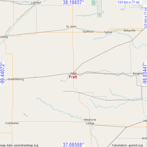
Pratt GPS coordinates[2]
37° 38' 38.076" North, 98° 44' 15.324" West
| Map corner | latitude | longitude |
|---|---|---|
| Upper-left | 38.19857°, | -99.44072° |
| Center: | 37.64391°, | -98.73759° |
| Lower-right: | 37.08508°, | -98.03447° |
| Map W x H: | 123.8×123.8 km | = 76.9×76.9mi |
| max Lat: | 71.29058° ⇑63.5% North |
| Pratt: | 37.64391° |
| min Lat: | ⇓36.5% South 19.06759° |
| min Long | Pratt | max Long |
| -171.73463° | -98.73759° | -66.98998° |
| W 20.3%⇐ | ⇒79.7% E |
Elevation
Elevation of Pratt is 582 m = 1909 ft, and this is 287.2 m = 942 ft above average elevation for this country.
| Max E: |
3189 m = 10463 ft | 10.6% |
| Pratt | 582 m 1909 ft | |
| Avg. | 294.8 m = 967 ft | |
Min E: |
-60 m = -197 ft | 89.4% |
See also: United States elevation on elevation.city.
Geographical zone
Pratt is located in North temperate zone (between Tropic of Cancer and the Arctic Circle). Distance of this Northern Tropic circle is 1579.7 km =981.6 mi to South.| Distance of | km | miles | from Pratt |
|---|---|---|---|
| North Pole | 5821.5 | 3617.3 | to North |
| Arctic Circle | 3215.6 | 1998.1 | to North |
| Tropic Cancer | 1579.7 | 981.6 | to South |
| Equator | 4185.6 | 2600.8 | to South |


Nearby cities:
15 places around Pratt: (largest is in red/bold)
• Attica
63.5 km =39.5 mi,  134°
134°
• Coldwater
66.7 km =41.4 mi,  231°
231°
• Greensburg
49.1 km =30.5 mi,  264°
264°
• Harper
74.3 km =46.2 mi,  122°
122°
• Haviland
32.6 km =20.3 mi,  265°
265°
• Kingman
54.9 km =34.1 mi,  89°
89°
• Kinsley
66.7 km =41.4 mi,  297°
297°
• Kiowa
73.2 km =45.5 mi,  162°
162°
• Larned
67.6 km =42 mi,  332°
332°
• Macksville
40.5 km =25.2 mi, 329°
• Medicine Lodge
42.7 km =26.5 mi, 161°
• Pretty Prairie
64.9 km =40.3 mi,  76°
76°
• Saint John
39.9 km =24.8 mi,  357°
357°
• Stafford
37.4 km =23.2 mi,  18°
18°
• Sterling
78.3 km =48.7 mi,  36°
36°
Sources, notices
• [Note1] Compared only with cities in United States existing in our database
• [Src1] Map data: © OpenStreetMap contributors (CC-BY-SA)
• [Src2] Other city data from geonames.org with taken over terms of usage.
• [Src3] Geographical zone / Annual Mean Temperature by Robert A. Rohde @ Wikipedia
