Howard geodata
Howard (Kansas) is a seat of a second-order administrative division; located in United States in America/Chicago (GMT-5) time zone. With population of 621 people, there are 19457 cities with bigger population in this country. Compared to other cities in United States, 64.2% of cities are located further ↑North; 74% of cities are located further →East and 76% of cities have lower elevation than Howard. Note1


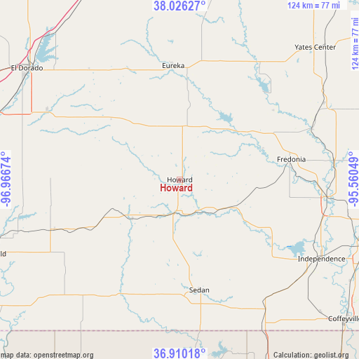
Howard GPS coordinates[2]
37° 28' 13.116" North, 96° 15' 48.996" West
| Map corner | latitude | longitude |
|---|---|---|
| Upper-left | 38.02627°, | -96.96674° |
| Center: | 37.47031°, | -96.26361° |
| Lower-right: | 36.91018°, | -95.56049° |
| Map W x H: | 124.1×124.1 km | = 77.1×77.1mi |
| max Lat: | 71.29058° ⇑64.2% North |
| Howard: | 37.47031° |
| min Lat: | ⇓35.8% South 19.06759° |
| min Long | Howard | max Long |
| -171.73463° | -96.26361° | -66.98998° |
| W 26%⇐ | ⇒74% E |
Elevation
Elevation of Howard is 320 m = 1050 ft, and this is 25.2 m = 83 ft above average elevation for this country.
| Max E: |
3189 m = 10463 ft | 24% |
| Howard | 320 m 1050 ft | |
| Avg. | 294.8 m = 967 ft | |
Min E: |
-60 m = -197 ft | 76% |
See also: United States elevation on elevation.city.
Geographical zone
Howard is located in North temperate zone (between Tropic of Cancer and the Arctic Circle). Distance of this Northern Tropic circle is 1560.4 km =969.6 mi to South.| Distance of | km | miles | from Howard |
|---|---|---|---|
| North Pole | 5840.8 | 3629.3 | to North |
| Arctic Circle | 3234.9 | 2010.1 | to North |
| Tropic Cancer | 1560.4 | 969.6 | to South |
| Equator | 4166.3 | 2588.8 | to South |


Nearby cities:
15 places around Howard: (largest is in red/bold)
• Augusta
67.3 km =41.8 mi,  290°
290°
• Burden
46.7 km =29 mi,  247°
247°
• Caney
58.7 km =36.5 mi,  150°
150°
• Cedar Vale
45.8 km =28.5 mi,  207°
207°
• Cherryvale
66.7 km =41.4 mi,  109°
109°
• Clay Center
45.1 km =28 mi,  276°
276°
• Douglass
66.3 km =41.2 mi,  274°
274°
• El Dorado
65.3 km =40.6 mi,  306°
306°
• Eureka
39.4 km =24.5 mi,  356°
356°
• Fredonia
39.2 km =24.4 mi,  79°
79°
• Independence
56.2 km =34.9 mi,  119°
119°
• Leon
51.8 km =32.2 mi,  298°
298°
• Neodesha
51.8 km =32.2 mi,  96°
96°
• Sedan
38.8 km =24.1 mi,  169°
169°
• Yates Center
65.3 km =40.6 mi,  45°
45°
Sources, notices
• [Note1] Compared only with cities in United States existing in our database
• [Src1] Map data: © OpenStreetMap contributors (CC-BY-SA)
• [Src2] Other city data from geonames.org with taken over terms of usage.
• [Src3] Geographical zone / Annual Mean Temperature by Robert A. Rohde @ Wikipedia
