Leon geodata
Leon (Kansas) is a populated place; located in United States in America/Chicago (GMT-5) time zone. With population of 701 people, there are 18667 cities with bigger population in this country. Compared to other cities in United States, 63.3% of cities are located further ↑North; 75.1% of cities are located further →East and 84.8% of cities have lower elevation than Leon. Note1
Administrative division(s):
- Level 1: Kansas
- Level 2: Butler County
- Level 3: Township of Little Walnut


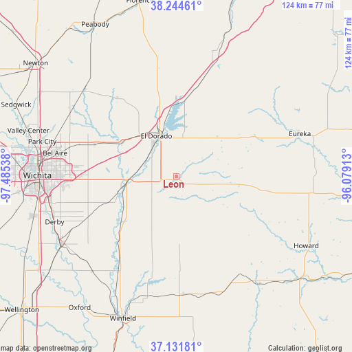
Leon GPS coordinates[2]
37° 41' 25.08" North, 96° 46' 56.1" West
| Map corner | latitude | longitude |
|---|---|---|
| Upper-left | 38.24461°, | -97.48538° |
| Center: | 37.6903°, | -96.78225° |
| Lower-right: | 37.13181°, | -96.07913° |
| Map W x H: | 123.7×123.7 km | = 76.9×76.9mi |
| max Lat: | 71.29058° ⇑63.3% North |
| Leon: | 37.6903° |
| min Lat: | ⇓36.7% South 19.06759° |
| min Long | Leon | max Long |
| -171.73463° | -96.78225° | -66.98998° |
| W 24.9%⇐ | ⇒75.1% E |
Elevation
Elevation of Leon is 419 m = 1375 ft, and this is 124.2 m = 407 ft above average elevation for this country.
| Max E: |
3189 m = 10463 ft | 15.2% |
| Leon | 419 m 1375 ft | |
| Avg. | 294.8 m = 967 ft | |
Min E: |
-60 m = -197 ft | 84.8% |
See also: United States elevation on elevation.city.
Geographical zone
Leon is located in North temperate zone (between Tropic of Cancer and the Arctic Circle). Distance of this Northern Tropic circle is 1584.8 km =984.7 mi to South.| Distance of | km | miles | from Leon |
|---|---|---|---|
| North Pole | 5816.3 | 3614.1 | to North |
| Arctic Circle | 3210.4 | 1994.8 | to North |
| Tropic Cancer | 1584.8 | 984.7 | to South |
| Equator | 4190.8 | 2604 | to South |


Nearby cities:
15 places around Leon: (largest is in red/bold)
• Andover
31.3 km =19.4 mi,  274°
274°
• Augusta
17.1 km =10.6 mi, 268°
• Bellaire
43.4 km =27 mi,  280°
280°
• Benton
30.7 km =19.1 mi,  290°
290°
• Burden
42 km =26.1 mi,  176°
176°
• Clay Center
19 km =11.8 mi, 177°
• Douglass
27.8 km =17.3 mi,  226°
226°
• Eastborough
42.4 km =26.3 mi, 269°
• El Dorado
15.8 km =9.8 mi,  333°
333°
• Kechi
45.3 km =28.1 mi, 285°
• McConnell AFB
42.5 km =26.4 mi,  260°
260°
• Rose Hill
34.4 km =21.4 mi,  244°
244°
• Towanda
22.5 km =14 mi,  301°
301°
• Udall
44.6 km =27.7 mi,  221°
221°
• Whitewater
44.3 km =27.5 mi,  313°
313°
Sources, notices
• [Note1] Compared only with cities in United States existing in our database
• [Src1] Map data: © OpenStreetMap contributors (CC-BY-SA)
• [Src2] Other city data from geonames.org with taken over terms of usage.
• [Src3] Geographical zone / Annual Mean Temperature by Robert A. Rohde @ Wikipedia
