Olathe geodata
Olathe (Kansas) is a seat of a second-order administrative division; located in United States in America/Chicago (GMT-5) time zone. With population of 134,305 people, there are 222 cities with bigger population in this country. Compared to other cities in United States, 56% of cities are located further ↑North; 70.7% of cities are located further →East and 76.5% of cities have lower elevation than Olathe. Note1


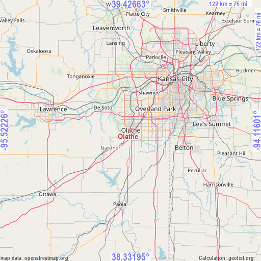
Olathe GPS coordinates[2]
38° 52' 53.04" North, 94° 49' 8.868" West
| Map corner | latitude | longitude |
|---|---|---|
| Upper-left | 39.42663°, | -95.52226° |
| Center: | 38.8814°, | -94.81913° |
| Lower-right: | 38.33195°, | -94.11601° |
| Map W x H: | 121.7×121.7 km | = 75.6×75.6mi |
| max Lat: | 71.29058° ⇑56% North |
| Olathe: | 38.8814° |
| min Lat: | ⇓44% South 19.06759° |
| min Long | Olathe | max Long |
| -171.73463° | -94.81913° | -66.98998° |
| W 29.3%⇐ | ⇒70.7% E |
Elevation
Elevation of Olathe is 324 m = 1063 ft, and this is 29.2 m = 96 ft above average elevation for this country.
| Max E: |
3189 m = 10463 ft | 23.5% |
| Olathe | 324 m 1063 ft | |
| Avg. | 294.8 m = 967 ft | |
Min E: |
-60 m = -197 ft | 76.5% |
See also: Olathe elevation on elevation.city.
Geographical zone
Olathe is located in North temperate zone (between Tropic of Cancer and the Arctic Circle). Distance of this Northern Tropic circle is 1717.3 km =1067.1 mi to South.| Distance of | km | miles | from Olathe |
|---|---|---|---|
| North Pole | 5683.9 | 3531.8 | to North |
| Arctic Circle | 3078 | 1912.6 | to North |
| Tropic Cancer | 1717.3 | 1067.1 | to South |
| Equator | 4323.2 | 2686.3 | to South |


Nearby cities:
15 places around Olathe: (largest is in red/bold)
• Bonner Springs
20.6 km =12.8 mi,  344°
344°
• De Soto
16.9 km =10.5 mi,  310°
310°
• Edgerton
20.9 km =13 mi,  231°
231°
• Edwardsville
20 km =12.4 mi,  359°
359°
• Gardner
12.2 km =7.6 mi, 230°
• Lake Quivira
18 km =11.2 mi,  11°
11°
• Leawood
19.9 km =12.4 mi,  61°
61°
• Lenexa
10.9 km =6.8 mi,  42°
42°
• Loch Lloyd
20 km =12.4 mi,  106°
106°
• Merriam
19.2 km =11.9 mi,  34°
34°
• New Century, KS
9.6 km =6 mi, 226°
• Overland Park
17 km =10.6 mi,  48°
48°
• Prairie Village
20.2 km =12.6 mi, 52°
• Shawnee
19.8 km =12.3 mi, 25°
• Spring Hill
15.4 km =9.6 mi,  182°
182°
Sources, notices
• [Note1] Compared only with cities in United States existing in our database
• [Src1] Map data: © OpenStreetMap contributors (CC-BY-SA)
• [Src2] Other city data from geonames.org with taken over terms of usage.
• [Src3] Geographical zone / Annual Mean Temperature by Robert A. Rohde @ Wikipedia
