Mound City geodata
Mound City (Kansas) is a seat of a second-order administrative division; located in United States in America/Chicago (GMT-5) time zone. With population of 680 people, there are 18874 cities with bigger population in this country. Compared to other cities in United States, 60.9% of cities are located further ↑North; 70.7% of cities are located further →East and 66.7% of cities have lower elevation than Mound City. Note1


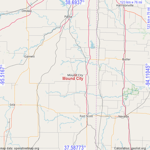
Mound City GPS coordinates[2]
38° 8' 34.116" North, 94° 48' 48.852" West
| Map corner | latitude | longitude |
|---|---|---|
| Upper-left | 38.6937°, | -95.5167° |
| Center: | 38.14281°, | -94.81357° |
| Lower-right: | 37.58773°, | -94.11045° |
| Map W x H: | 123×123 km | = 76.4×76.4mi |
| max Lat: | 71.29058° ⇑60.9% North |
| Mound City: | 38.14281° |
| min Lat: | ⇓39.1% South 19.06759° |
| min Long | Mound City | max Long |
| -171.73463° | -94.81357° | -66.98998° |
| W 29.3%⇐ | ⇒70.7% E |
Elevation
Elevation of Mound City is 270 m = 886 ft, and this is 24.8 m = 81 ft below average elevation for this country.
| Max E: |
3189 m = 10463 ft | 33.3% |
| Avg. | 294.8 m = 967 ft | |
| Mound City | 270 m = 886 ft | |
Min E: |
-60 m = -197 ft | 66.7% |
See also: United States elevation on elevation.city.
Geographical zone
Mound City is located in North temperate zone (between Tropic of Cancer and the Arctic Circle). Distance of this Northern Tropic circle is 1635.2 km =1016.1 mi to South.| Distance of | km | miles | from Mound City |
|---|---|---|---|
| North Pole | 5766 | 3582.8 | to North |
| Arctic Circle | 3160.1 | 1963.6 | to North |
| Tropic Cancer | 1635.2 | 1016.1 | to South |
| Equator | 4241.1 | 2635.3 | to South |


Nearby cities:
15 places around Mound City: (largest is in red/bold)
• Adrian
49.3 km =30.6 mi,  54°
54°
• Butler
44.1 km =27.4 mi,  73°
73°
• Drexel
41.5 km =25.8 mi,  25°
25°
• Fort Scott
34.9 km =21.7 mi,  164°
164°
• Garnett
40.4 km =25.1 mi,  292°
292°
• Gas
52.6 km =32.7 mi,  242°
242°
• La Cygne
23.5 km =14.6 mi,  11°
11°
• La Harpe
49.4 km =30.7 mi, 239°
• Linn Valley
27.6 km =17.1 mi,  19°
19°
• Moran
40.1 km =24.9 mi,  231°
231°
• Nevada
52.5 km =32.6 mi,  130°
130°
• Osawatomie
41.2 km =25.6 mi,  343°
343°
• Paola
48.1 km =29.9 mi,  353°
353°
• Pleasanton
9.7 km =6 mi, 66°
• Rich Hill
39.9 km =24.8 mi,  97°
97°
Sources, notices
• [Note1] Compared only with cities in United States existing in our database
• [Src1] Map data: © OpenStreetMap contributors (CC-BY-SA)
• [Src2] Other city data from geonames.org with taken over terms of usage.
• [Src3] Geographical zone / Annual Mean Temperature by Robert A. Rohde @ Wikipedia
