Gas geodata
Gas (Kansas) is a populated place; located in United States in America/Chicago (GMT-5) time zone. With population of 522 people, there are 20606 cities with bigger population in this country. Compared to other cities in United States, 62.1% of cities are located further ↑North; 71.9% of cities are located further →East and 75% of cities have lower elevation than Gas. Note1


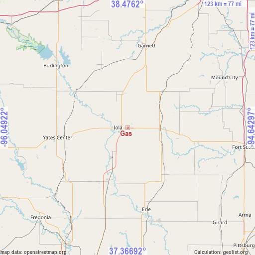
Gas GPS coordinates[2]
37° 55' 25.14" North, 95° 20' 45.924" West
| Map corner | latitude | longitude |
|---|---|---|
| Upper-left | 38.4762°, | -96.04922° |
| Center: | 37.92365°, | -95.34609° |
| Lower-right: | 37.36692°, | -94.64297° |
| Map W x H: | 123.3×123.3 km | = 76.6×76.6mi |
| max Lat: | 71.29058° ⇑62.1% North |
| Gas: | 37.92365° |
| min Lat: | ⇓37.9% South 19.06759° |
| min Long | Gas | max Long |
| -171.73463° | -95.34609° | -66.98998° |
| W 28.1%⇐ | ⇒71.9% E |
Elevation
Elevation of Gas is 313 m = 1027 ft, and this is 18.2 m = 60 ft above average elevation for this country.
| Max E: |
3189 m = 10463 ft | 25% |
| Gas | 313 m 1027 ft | |
| Avg. | 294.8 m = 967 ft | |
Min E: |
-60 m = -197 ft | 75% |
See also: United States elevation on elevation.city.
Geographical zone
Gas is located in North temperate zone (between Tropic of Cancer and the Arctic Circle). Distance of this Northern Tropic circle is 1610.8 km =1000.9 mi to South.| Distance of | km | miles | from Gas |
|---|---|---|---|
| North Pole | 5790.3 | 3597.9 | to North |
| Arctic Circle | 3184.5 | 1978.8 | to North |
| Tropic Cancer | 1610.8 | 1000.9 | to South |
| Equator | 4216.7 | 2620.1 | to South |


Nearby cities:
15 places around Gas: (largest is in red/bold)
• Burlington
46 km =28.6 mi,  310°
310°
• Chanute
28.9 km =18 mi,  199°
199°
• Erie
40.6 km =25.2 mi,  167°
167°
• Fort Scott
56.7 km =35.2 mi,  99°
99°
• Fredonia
60.5 km =37.6 mi,  224°
224°
• Garnett
40.7 km =25.3 mi,  12°
12°
• Humboldt
14.9 km =9.3 mi,  212°
212°
• Iola
4.7 km =2.9 mi,  271°
271°
• La Harpe
4.2 km =2.6 mi, 100°
• LeRoy
30.9 km =19.2 mi, 305°
• Moran
15.4 km =9.6 mi,  93°
93°
• Mound City
52.6 km =32.7 mi,  62°
62°
• Saint Paul
47.5 km =29.5 mi,  161°
161°
• Waverly
56.9 km =35.4 mi,  336°
336°
• Yates Center
34.3 km =21.3 mi,  262°
262°
Sources, notices
• [Note1] Compared only with cities in United States existing in our database
• [Src1] Map data: © OpenStreetMap contributors (CC-BY-SA)
• [Src2] Other city data from geonames.org with taken over terms of usage.
• [Src3] Geographical zone / Annual Mean Temperature by Robert A. Rohde @ Wikipedia
