Osawatomie geodata
Osawatomie (Kansas) is a populated place; located in United States in America/Chicago (GMT-5) time zone. With population of 4,297 people, there are 7869 cities with bigger population in this country. Compared to other cities in United States, 58.8% of cities are located further ↑North; 71% of cities are located further →East and 66.3% of cities have lower elevation than Osawatomie. Note1


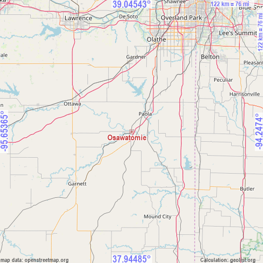
Osawatomie GPS coordinates[2]
38° 29' 50.064" North, 94° 57' 1.872" West
| Map corner | latitude | longitude |
|---|---|---|
| Upper-left | 39.04543°, | -95.65365° |
| Center: | 38.49724°, | -94.95052° |
| Lower-right: | 37.94485°, | -94.2474° |
| Map W x H: | 122.4×122.4 km | = 76.1×76.1mi |
| max Lat: | 71.29058° ⇑58.8% North |
| Osawatomie: | 38.49724° |
| min Lat: | ⇓41.2% South 19.06759° |
| min Long | Osawatomie | max Long |
| -171.73463° | -94.95052° | -66.98998° |
| W 29%⇐ | ⇒71% E |
Elevation
Elevation of Osawatomie is 268 m = 879 ft, and this is 26.8 m = 88 ft below average elevation for this country.
| Max E: |
3189 m = 10463 ft | 33.7% |
| Avg. | 294.8 m = 967 ft | |
| Osawatomie | 268 m = 879 ft | |
Min E: |
-60 m = -197 ft | 66.3% |
See also: United States elevation on elevation.city.
Geographical zone
Osawatomie is located in North temperate zone (between Tropic of Cancer and the Arctic Circle). Distance of this Northern Tropic circle is 1674.6 km =1040.5 mi to South.| Distance of | km | miles | from Osawatomie |
|---|---|---|---|
| North Pole | 5726.6 | 3558.3 | to North |
| Arctic Circle | 3120.7 | 1939.1 | to North |
| Tropic Cancer | 1674.6 | 1040.5 | to South |
| Equator | 4280.5 | 2659.8 | to South |


Nearby cities:
15 places around Osawatomie: (largest is in red/bold)
• Baldwin City
37.1 km =23.1 mi,  326°
326°
• Cleveland
37 km =23 mi,  56°
56°
• Drexel
29.8 km =18.5 mi,  93°
93°
• Edgerton
30.2 km =18.8 mi,  350°
350°
• Gardner
34.9 km =21.7 mi,  3°
3°
• Garnett
35 km =21.7 mi,  226°
226°
• La Cygne
23.2 km =14.4 mi,  134°
134°
• Linn Valley
24.9 km =15.5 mi,  122°
122°
• Louisburg
27.1 km =16.8 mi, 59°
• New Century, KS
36.4 km =22.6 mi,  6°
6°
• Ottawa
30.6 km =19 mi,  295°
295°
• Paola
10.4 km =6.5 mi,  36°
36°
• Pleasanton
41.2 km =25.6 mi,  149°
149°
• Spring Hill
29.4 km =18.3 mi,  21°
21°
• Wellsville
27.1 km =16.8 mi,  335°
335°
Sources, notices
• [Note1] Compared only with cities in United States existing in our database
• [Src1] Map data: © OpenStreetMap contributors (CC-BY-SA)
• [Src2] Other city data from geonames.org with taken over terms of usage.
• [Src3] Geographical zone / Annual Mean Temperature by Robert A. Rohde @ Wikipedia
