Garnett geodata
Garnett (Kansas) is a seat of a second-order administrative division; located in United States in America/Chicago (GMT-5) time zone. With population of 3,258 people, there are 9213 cities with bigger population in this country. Compared to other cities in United States, 60.1% of cities are located further ↑North; 71.7% of cities are located further →East and 77.3% of cities have lower elevation than Garnett. Note1


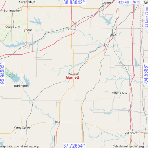
Garnett GPS coordinates[2]
38° 16' 50.088" North, 95° 14' 30.912" West
| Map corner | latitude | longitude |
|---|---|---|
| Upper-left | 38.83042°, | -95.94505° |
| Center: | 38.28058°, | -95.24192° |
| Lower-right: | 37.72654°, | -94.5388° |
| Map W x H: | 122.7×122.7 km | = 76.2×76.2mi |
| max Lat: | 71.29058° ⇑60.1% North |
| Garnett: | 38.28058° |
| min Lat: | ⇓39.9% South 19.06759° |
| min Long | Garnett | max Long |
| -171.73463° | -95.24192° | -66.98998° |
| W 28.3%⇐ | ⇒71.7% E |
Elevation
Elevation of Garnett is 330 m = 1083 ft, and this is 35.2 m = 115 ft above average elevation for this country.
| Max E: |
3189 m = 10463 ft | 22.7% |
| Garnett | 330 m 1083 ft | |
| Avg. | 294.8 m = 967 ft | |
Min E: |
-60 m = -197 ft | 77.3% |
See also: United States elevation on elevation.city.
Geographical zone
Garnett is located in North temperate zone (between Tropic of Cancer and the Arctic Circle). Distance of this Northern Tropic circle is 1650.5 km =1025.6 mi to South.| Distance of | km | miles | from Garnett |
|---|---|---|---|
| North Pole | 5750.7 | 3573.3 | to North |
| Arctic Circle | 3144.8 | 1954.1 | to North |
| Tropic Cancer | 1650.5 | 1025.6 | to South |
| Equator | 4256.4 | 2644.8 | to South |


Nearby cities:
15 places around Garnett: (largest is in red/bold)
• Burlington
44.8 km =27.8 mi,  257°
257°
• Gas
40.7 km =25.3 mi,  192°
192°
• Iola
41.9 km =26 mi,  199°
199°
• La Cygne
42.6 km =26.5 mi,  79°
79°
• La Harpe
40.7 km =25.3 mi, 187°
• LeRoy
40.7 km =25.3 mi,  237°
237°
• Linn Valley
47.7 km =29.6 mi, 76°
• Moran
41 km =25.5 mi,  171°
171°
• Mound City
40.4 km =25.1 mi,  112°
112°
• Osawatomie
35 km =21.7 mi,  46°
46°
• Ottawa
37.3 km =23.2 mi,  356°
356°
• Paola
45.3 km =28.1 mi,  44°
44°
• Pomona
39.6 km =24.6 mi,  332°
332°
• Pomona
40.8 km =25.4 mi, 333°
• Waverly
33.9 km =21.1 mi,  291°
291°
Sources, notices
• [Note1] Compared only with cities in United States existing in our database
• [Src1] Map data: © OpenStreetMap contributors (CC-BY-SA)
• [Src2] Other city data from geonames.org with taken over terms of usage.
• [Src3] Geographical zone / Annual Mean Temperature by Robert A. Rohde @ Wikipedia
