Sterling geodata
Sterling (Kansas) is a populated place; located in United States in America/Chicago (GMT-5) time zone. With population of 2,293 people, there are 11094 cities with bigger population in this country. Compared to other cities in United States, 60.6% of cities are located further ↑North; 78.9% of cities are located further →East and 87.9% of cities have lower elevation than Sterling. Note1


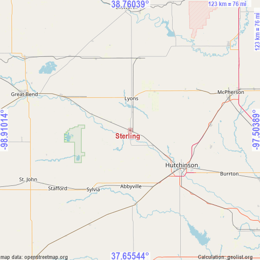
Sterling GPS coordinates[2]
38° 12' 36.036" North, 98° 12' 25.236" West
| Map corner | latitude | longitude |
|---|---|---|
| Upper-left | 38.76039°, | -98.91014° |
| Center: | 38.21001°, | -98.20701° |
| Lower-right: | 37.65544°, | -97.50389° |
| Map W x H: | 122.9×122.9 km | = 76.4×76.4mi |
| max Lat: | 71.29058° ⇑60.6% North |
| Sterling: | 38.21001° |
| min Lat: | ⇓39.4% South 19.06759° |
| min Long | Sterling | max Long |
| -171.73463° | -98.20701° | -66.98998° |
| W 21.1%⇐ | ⇒78.9% E |
Elevation
Elevation of Sterling is 504 m = 1654 ft, and this is 209.2 m = 686 ft above average elevation for this country.
| Max E: |
3189 m = 10463 ft | 12.1% |
| Sterling | 504 m 1654 ft | |
| Avg. | 294.8 m = 967 ft | |
Min E: |
-60 m = -197 ft | 87.9% |
See also: United States elevation on elevation.city.
Geographical zone
Sterling is located in North temperate zone (between Tropic of Cancer and the Arctic Circle). Distance of this Northern Tropic circle is 1642.6 km =1020.7 mi to South.| Distance of | km | miles | from Sterling |
|---|---|---|---|
| North Pole | 5758.5 | 3578.2 | to North |
| Arctic Circle | 3152.6 | 1958.9 | to North |
| Tropic Cancer | 1642.6 | 1020.7 | to South |
| Equator | 4248.6 | 2640 | to South |


Nearby cities:
15 places around Sterling: (largest is in red/bold)
• Buhler
39.1 km =24.3 mi,  102°
102°
• Burrton
51.4 km =31.9 mi,  113°
113°
• Claflin
45.1 km =28 mi,  320°
320°
• Ellinwood
36.4 km =22.6 mi,  296°
296°
• Haven
50.8 km =31.6 mi,  132°
132°
• Hutchinson
29.4 km =18.3 mi,  124°
124°
• Inman
38 km =23.6 mi,  86°
86°
• Little River
27 km =16.8 mi,  39°
39°
• Lyons
15 km =9.3 mi,  1°
1°
• Marquette
50.3 km =31.3 mi, 40°
• McPherson
50.6 km =31.4 mi,  69°
69°
• Nickerson
12.8 km =8 mi, 122°
• Pretty Prairie
50.5 km =31.4 mi,  161°
161°
• South Hutchinson
30.9 km =19.2 mi, 130°
• Stafford
44.1 km =27.4 mi,  231°
231°
Sources, notices
• [Note1] Compared only with cities in United States existing in our database
• [Src1] Map data: © OpenStreetMap contributors (CC-BY-SA)
• [Src2] Other city data from geonames.org with taken over terms of usage.
• [Src3] Geographical zone / Annual Mean Temperature by Robert A. Rohde @ Wikipedia
