Russell geodata
Russell (Kansas) is a seat of a second-order administrative division; located in United States in America/Chicago (GMT-5) time zone. With population of 4,534 people, there are 7609 cities with bigger population in this country. Compared to other cities in United States, 55.8% of cities are located further ↑North; 79.8% of cities are located further →East and 89% of cities have lower elevation than Russell. Note1


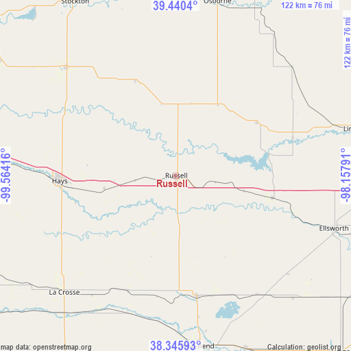
Russell GPS coordinates[2]
38° 53' 42.972" North, 98° 51' 39.708" West
| Map corner | latitude | longitude |
|---|---|---|
| Upper-left | 39.4404°, | -99.56416° |
| Center: | 38.89527°, | -98.86103° |
| Lower-right: | 38.34593°, | -98.15791° |
| Map W x H: | 121.7×121.7 km | = 75.6×75.6mi |
| max Lat: | 71.29058° ⇑55.8% North |
| Russell: | 38.89527° |
| min Lat: | ⇓44.2% South 19.06759° |
| min Long | Russell | max Long |
| -171.73463° | -98.86103° | -66.98998° |
| W 20.2%⇐ | ⇒79.8% E |
Elevation
Elevation of Russell is 563 m = 1847 ft, and this is 268.2 m = 880 ft above average elevation for this country.
| Max E: |
3189 m = 10463 ft | 11% |
| Russell | 563 m 1847 ft | |
| Avg. | 294.8 m = 967 ft | |
Min E: |
-60 m = -197 ft | 89% |
See also: United States elevation on elevation.city.
Geographical zone
Russell is located in North temperate zone (between Tropic of Cancer and the Arctic Circle). Distance of this Northern Tropic circle is 1718.8 km =1068 mi to South.| Distance of | km | miles | from Russell |
|---|---|---|---|
| North Pole | 5682.3 | 3530.8 | to North |
| Arctic Circle | 3076.4 | 1911.6 | to North |
| Tropic Cancer | 1718.8 | 1068 | to South |
| Equator | 4324.7 | 2687.2 | to South |


Nearby cities:
15 places around Russell: (largest is in red/bold)
• Claflin
50 km =31.1 mi,  145°
145°
• Downs
72.5 km =45 mi,  22°
22°
• Ellinwood
64.8 km =40.3 mi,  157°
157°
• Ellis
60.7 km =37.7 mi,  274°
274°
• Ellsworth
57.8 km =35.9 mi,  108°
108°
• Great Bend
59.6 km =37 mi,  171°
171°
• Hays
40.3 km =25 mi, 267°
• Hoisington
42.6 km =26.5 mi, 170°
• La Crosse
56.1 km =34.9 mi,  223°
223°
• Lincoln
64 km =39.8 mi,  75°
75°
• Osborne
62.1 km =38.6 mi,  13°
13°
• Plainville
53.4 km =33.2 mi,  315°
315°
• Stockton
69.7 km =43.3 mi,  330°
330°
• Victoria
25.3 km =15.7 mi,  259°
259°
• Wilson
34.3 km =21.3 mi,  103°
103°
Sources, notices
• [Note1] Compared only with cities in United States existing in our database
• [Src1] Map data: © OpenStreetMap contributors (CC-BY-SA)
• [Src2] Other city data from geonames.org with taken over terms of usage.
• [Src3] Geographical zone / Annual Mean Temperature by Robert A. Rohde @ Wikipedia
