Ellinwood geodata
Ellinwood (Kansas) is a populated place; located in United States in America/Chicago (GMT-5) time zone. With population of 2,066 people, there are 11732 cities with bigger population in this country. Compared to other cities in United States, 59.6% of cities are located further ↑North; 79.5% of cities are located further →East and 88.9% of cities have lower elevation than Ellinwood. Note1


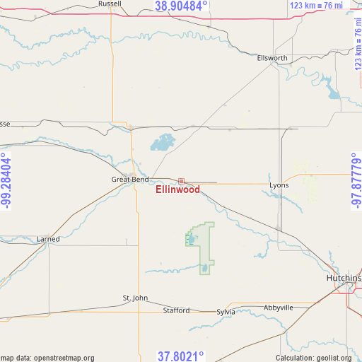
Ellinwood GPS coordinates[2]
38° 21' 20.052" North, 98° 34' 51.276" West
| Map corner | latitude | longitude |
|---|---|---|
| Upper-left | 38.90484°, | -99.28404° |
| Center: | 38.35557°, | -98.58091° |
| Lower-right: | 37.8021°, | -97.87779° |
| Map W x H: | 122.6×122.6 km | = 76.2×76.2mi |
| max Lat: | 71.29058° ⇑59.6% North |
| Ellinwood: | 38.35557° |
| min Lat: | ⇓40.4% South 19.06759° |
| min Long | Ellinwood | max Long |
| -171.73463° | -98.58091° | -66.98998° |
| W 20.5%⇐ | ⇒79.5% E |
Elevation
Elevation of Ellinwood is 552 m = 1811 ft, and this is 257.2 m = 844 ft above average elevation for this country.
| Max E: |
3189 m = 10463 ft | 11.1% |
| Ellinwood | 552 m 1811 ft | |
| Avg. | 294.8 m = 967 ft | |
Min E: |
-60 m = -197 ft | 88.9% |
See also: United States elevation on elevation.city.
Geographical zone
Ellinwood is located in North temperate zone (between Tropic of Cancer and the Arctic Circle). Distance of this Northern Tropic circle is 1658.8 km =1030.7 mi to South.| Distance of | km | miles | from Ellinwood |
|---|---|---|---|
| North Pole | 5742.3 | 3568.1 | to North |
| Arctic Circle | 3136.4 | 1948.9 | to North |
| Tropic Cancer | 1658.8 | 1030.7 | to South |
| Equator | 4264.7 | 2650 | to South |


Nearby cities:
15 places around Ellinwood: (largest is in red/bold)
• Claflin
19.3 km =12 mi,  12°
12°
• Ellsworth
51.8 km =32.2 mi,  36°
36°
• Great Bend
16.1 km =10 mi,  273°
273°
• Hoisington
24.9 km =15.5 mi,  316°
316°
• Hutchinson
65.7 km =40.8 mi,  119°
119°
• Larned
49.2 km =30.6 mi,  246°
246°
• Little River
49.8 km =30.9 mi,  84°
84°
• Lyons
33.1 km =20.6 mi,  92°
92°
• Macksville
55.6 km =34.5 mi,  217°
217°
• Nickerson
49.2 km =30.6 mi, 118°
• Russell
64.8 km =40.3 mi,  337°
337°
• Saint John
42.3 km =26.3 mi,  201°
201°
• Stafford
43.8 km =27.2 mi,  182°
182°
• Sterling
36.4 km =22.6 mi, 116°
• Wilson
53 km =32.9 mi, 9°
Sources, notices
• [Note1] Compared only with cities in United States existing in our database
• [Src1] Map data: © OpenStreetMap contributors (CC-BY-SA)
• [Src2] Other city data from geonames.org with taken over terms of usage.
• [Src3] Geographical zone / Annual Mean Temperature by Robert A. Rohde @ Wikipedia
