Ellsworth geodata
Ellsworth (Kansas) is a seat of a second-order administrative division; located in United States in America/Chicago (GMT-5) time zone. With population of 3,057 people, there are 9542 cities with bigger population in this country. Compared to other cities in United States, 57.1% of cities are located further ↑North; 78.9% of cities are located further →East and 87.3% of cities have lower elevation than Ellsworth. Note1


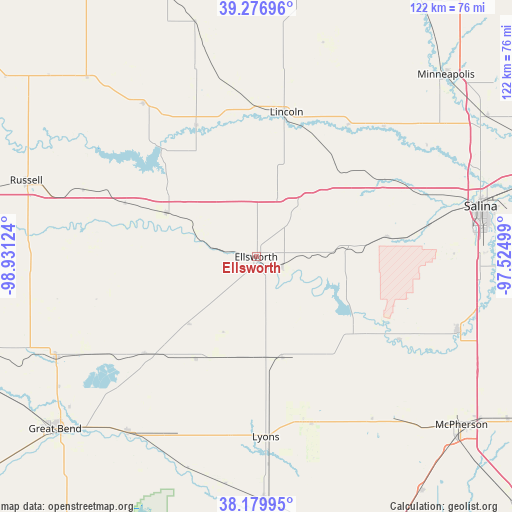
Ellsworth GPS coordinates[2]
38° 43' 50.016" North, 98° 13' 41.196" West
| Map corner | latitude | longitude |
|---|---|---|
| Upper-left | 39.27696°, | -98.93124° |
| Center: | 38.73056°, | -98.22811° |
| Lower-right: | 38.17995°, | -97.52499° |
| Map W x H: | 122×122 km | = 75.8×75.8mi |
| max Lat: | 71.29058° ⇑57.1% North |
| Ellsworth: | 38.73056° |
| min Lat: | ⇓42.9% South 19.06759° |
| min Long | Ellsworth | max Long |
| -171.73463° | -98.22811° | -66.98998° |
| W 21.1%⇐ | ⇒78.9% E |
Elevation
Elevation of Ellsworth is 476 m = 1562 ft, and this is 181.2 m = 594 ft above average elevation for this country.
| Max E: |
3189 m = 10463 ft | 12.7% |
| Ellsworth | 476 m 1562 ft | |
| Avg. | 294.8 m = 967 ft | |
Min E: |
-60 m = -197 ft | 87.3% |
See also: United States elevation on elevation.city.
Geographical zone
Ellsworth is located in North temperate zone (between Tropic of Cancer and the Arctic Circle). Distance of this Northern Tropic circle is 1700.5 km =1056.6 mi to South.| Distance of | km | miles | from Ellsworth |
|---|---|---|---|
| North Pole | 5700.6 | 3542.2 | to North |
| Arctic Circle | 3094.7 | 1923 | to North |
| Tropic Cancer | 1700.5 | 1056.6 | to South |
| Equator | 4306.4 | 2675.9 | to South |


Nearby cities:
15 places around Ellsworth: (largest is in red/bold)
• Claflin
35 km =21.7 mi,  229°
229°
• Ellinwood
51.8 km =32.2 mi,  216°
216°
• Great Bend
61.9 km =38.5 mi, 228°
• Hoisington
53.3 km =33.1 mi,  243°
243°
• Lincoln
35.2 km =21.9 mi,  11°
11°
• Lindsborg
51.1 km =31.8 mi,  109°
109°
• Little River
41.5 km =25.8 mi,  153°
153°
• Lyons
42.9 km =26.7 mi,  176°
176°
• Marquette
39.4 km =24.5 mi,  119°
119°
• McPherson
63.3 km =39.3 mi,  129°
129°
• Minneapolis
62.7 km =39 mi,  46°
46°
• Russell
57.8 km =35.9 mi,  288°
288°
• Salina
54.8 km =34.1 mi,  77°
77°
• Sterling
57.9 km =36 mi, 178°
• Wilson
23.9 km =14.9 mi,  296°
296°
Sources, notices
• [Note1] Compared only with cities in United States existing in our database
• [Src1] Map data: © OpenStreetMap contributors (CC-BY-SA)
• [Src2] Other city data from geonames.org with taken over terms of usage.
• [Src3] Geographical zone / Annual Mean Temperature by Robert A. Rohde @ Wikipedia
