La Crosse geodata
La Crosse (Kansas) is a seat of a second-order administrative division; located in United States in America/Chicago (GMT-5) time zone. With population of 1,262 people, there are 14780 cities with bigger population in this country. Compared to other cities in United States, 58.6% of cities are located further ↑North; 80.2% of cities are located further →East and 90.1% of cities have lower elevation than La Crosse. Note1
Administrative division(s):
- Level 1: Kansas
- Level 2: Rush County
- Level 3: Township of La Crosse-Brookdale


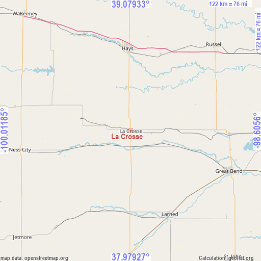
La Crosse GPS coordinates[2]
38° 31' 53.04" North, 99° 18' 31.392" West
| Map corner | latitude | longitude |
|---|---|---|
| Upper-left | 39.07933°, | -100.01185° |
| Center: | 38.5314°, | -99.30872° |
| Lower-right: | 37.97927°, | -98.6056° |
| Map W x H: | 122.3×122.3 km | = 76×76mi |
| max Lat: | 71.29058° ⇑58.6% North |
| La Crosse: | 38.5314° |
| min Lat: | ⇓41.4% South 19.06759° |
| min Long | La Crosse | max Long |
| -171.73463° | -99.30872° | -66.98998° |
| W 19.8%⇐ | ⇒80.2% E |
Elevation
Elevation of La Crosse is 632 m = 2073 ft, and this is 337.2 m = 1106 ft above average elevation for this country.
| Max E: |
3189 m = 10463 ft | 9.9% |
| La Crosse | 632 m 2073 ft | |
| Avg. | 294.8 m = 967 ft | |
Min E: |
-60 m = -197 ft | 90.1% |
See also: United States elevation on elevation.city.
Geographical zone
La Crosse is located in North temperate zone (between Tropic of Cancer and the Arctic Circle). Distance of this Northern Tropic circle is 1678.4 km =1042.9 mi to South.| Distance of | km | miles | from La Crosse |
|---|---|---|---|
| North Pole | 5722.8 | 3556 | to North |
| Arctic Circle | 3116.9 | 1936.8 | to North |
| Tropic Cancer | 1678.4 | 1042.9 | to South |
| Equator | 4284.3 | 2662.1 | to South |


Nearby cities:
15 places around La Crosse: (largest is in red/bold)
• Claflin
67.4 km =41.9 mi,  90°
90°
• Ellinwood
66.3 km =41.2 mi,  107°
107°
• Ellis
50.2 km =31.2 mi,  334°
334°
• Great Bend
50.9 km =31.6 mi, 111°
• Hays
38.7 km =24 mi,  357°
357°
• Hoisington
46.2 km =28.7 mi, 91°
• Jetmore
71.2 km =44.2 mi,  225°
225°
• Kinsley
68.2 km =42.4 mi,  187°
187°
• Larned
43.1 km =26.8 mi,  154°
154°
• Macksville
70.2 km =43.6 mi, 154°
• Ness City
52.8 km =32.8 mi,  260°
260°
• Russell
56.1 km =34.9 mi,  43°
43°
• Saint John
75.9 km =47.2 mi,  140°
140°
• Victoria
38.4 km =23.9 mi,  21°
21°
• WaKeeney
73.9 km =45.9 mi,  317°
317°
Sources, notices
• [Note1] Compared only with cities in United States existing in our database
• [Src1] Map data: © OpenStreetMap contributors (CC-BY-SA)
• [Src2] Other city data from geonames.org with taken over terms of usage.
• [Src3] Geographical zone / Annual Mean Temperature by Robert A. Rohde @ Wikipedia
