Winchester geodata
Winchester (Kansas) is a populated place; located in United States in America/Chicago (GMT-5) time zone. With population of 535 people, there are 20452 cities with bigger population in this country. Compared to other cities in United States, 52.1% of cities are located further ↑North; 71.8% of cities are located further →East and 80.9% of cities have lower elevation than Winchester. Note1
Administrative division(s):
- Level 1: Kansas
- Level 2: Jefferson County
- Level 3: Township of Jefferson


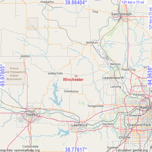
Winchester GPS coordinates[2]
39° 19' 19.992" North, 95° 16' 0.912" West
| Map corner | latitude | longitude |
|---|---|---|
| Upper-left | 39.86404°, | -95.97005° |
| Center: | 39.32222°, | -95.26692° |
| Lower-right: | 38.77617°, | -94.5638° |
| Map W x H: | 121×121 km | = 75.2×75.2mi |
| max Lat: | 71.29058° ⇑52.1% North |
| Winchester: | 39.32222° |
| min Lat: | ⇓47.9% South 19.06759° |
| min Long | Winchester | max Long |
| -171.73463° | -95.26692° | -66.98998° |
| W 28.2%⇐ | ⇒71.8% E |
Elevation
Elevation of Winchester is 363 m = 1191 ft, and this is 68.2 m = 224 ft above average elevation for this country.
| Max E: |
3189 m = 10463 ft | 19.1% |
| Winchester | 363 m 1191 ft | |
| Avg. | 294.8 m = 967 ft | |
Min E: |
-60 m = -197 ft | 80.9% |
See also: United States elevation on elevation.city.
Geographical zone
Winchester is located in North temperate zone (between Tropic of Cancer and the Arctic Circle). Distance of this Northern Tropic circle is 1766.3 km =1097.5 mi to South.| Distance of | km | miles | from Winchester |
|---|---|---|---|
| North Pole | 5634.8 | 3501.3 | to North |
| Arctic Circle | 3029 | 1882.1 | to North |
| Tropic Cancer | 1766.3 | 1097.5 | to South |
| Equator | 4372.2 | 2716.8 | to South |


Nearby cities:
15 places around Winchester: (largest is in red/bold)
• Atchison
29.5 km =18.3 mi,  24°
24°
• Basehor
34.7 km =21.6 mi,  125°
125°
• Effingham
25 km =15.5 mi,  332°
332°
• Lansing
32.6 km =20.3 mi,  104°
104°
• Leavenworth
29.7 km =18.5 mi,  92°
92°
• Lecompton
32.8 km =20.4 mi,  199°
199°
• McLouth
14.9 km =9.3 mi,  160°
160°
• Meriden
30 km =18.6 mi,  240°
240°
• Nortonville
12 km =7.5 mi, 331°
• Oskaloosa
12.5 km =7.8 mi, 198°
• Ozawkie
19.8 km =12.3 mi, 240°
• Perry
29.5 km =18.3 mi, 201°
• Tonganoxie
28.2 km =17.5 mi,  146°
146°
• Valley Falls
16.8 km =10.4 mi,  278°
278°
• Weston
32.9 km =20.4 mi,  72°
72°
Sources, notices
• [Note1] Compared only with cities in United States existing in our database
• [Src1] Map data: © OpenStreetMap contributors (CC-BY-SA)
• [Src2] Other city data from geonames.org with taken over terms of usage.
• [Src3] Geographical zone / Annual Mean Temperature by Robert A. Rohde @ Wikipedia
