Westmoreland geodata
Westmoreland (Kansas) is a seat of a second-order administrative division; located in United States in America/Chicago (GMT-5) time zone. With population of 774 people, there are 18032 cities with bigger population in this country. Compared to other cities in United States, 51.6% of cities are located further ↑North; 74.3% of cities are located further →East and 81.5% of cities have lower elevation than Westmoreland. Note1
Administrative division(s):
- Level 1: Kansas
- Level 2: Pottawatomie County
- Level 3: Township of Rock Creek


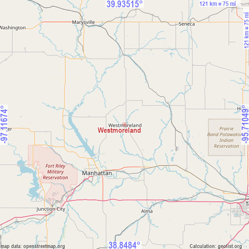
Westmoreland GPS coordinates[2]
39° 23' 38.004" North, 96° 24' 48.996" West
| Map corner | latitude | longitude |
|---|---|---|
| Upper-left | 39.93515°, | -97.11674° |
| Center: | 39.39389°, | -96.41361° |
| Lower-right: | 38.8484°, | -95.71049° |
| Map W x H: | 120.8×120.8 km | = 75.1×75.1mi |
| max Lat: | 71.29058° ⇑51.6% North |
| Westmoreland: | 39.39389° |
| min Lat: | ⇓48.4% South 19.06759° |
| min Long | Westmoreland | max Long |
| -171.73463° | -96.41361° | -66.98998° |
| W 25.7%⇐ | ⇒74.3% E |
Elevation
Elevation of Westmoreland is 370 m = 1214 ft, and this is 75.2 m = 247 ft above average elevation for this country.
| Max E: |
3189 m = 10463 ft | 18.5% |
| Westmoreland | 370 m 1214 ft | |
| Avg. | 294.8 m = 967 ft | |
Min E: |
-60 m = -197 ft | 81.5% |
See also: United States elevation on elevation.city.
Geographical zone
Westmoreland is located in North temperate zone (between Tropic of Cancer and the Arctic Circle). Distance of this Northern Tropic circle is 1774.3 km =1102.5 mi to South.| Distance of | km | miles | from Westmoreland |
|---|---|---|---|
| North Pole | 5626.9 | 3496.4 | to North |
| Arctic Circle | 3021 | 1877.2 | to North |
| Tropic Cancer | 1774.3 | 1102.5 | to South |
| Equator | 4380.2 | 2721.7 | to South |


Nearby cities:
15 places around Westmoreland: (largest is in red/bold)
• Alma
43.3 km =26.9 mi,  165°
165°
• Blue Rapids
38.4 km =23.9 mi,  326°
326°
• Centralia
44.3 km =27.5 mi,  33°
33°
• Fort Riley North
46.7 km =29 mi,  227°
227°
• Frankfort
34.7 km =21.6 mi,  359°
359°
• Manhattan
27 km =16.8 mi,  210°
210°
• Maple Hill
47.8 km =29.7 mi,  135°
135°
• Ogden
40.3 km =25 mi,  218°
218°
• Onaga
23.4 km =14.5 mi,  63°
63°
• Riley
37.4 km =23.2 mi,  253°
253°
• Rossville
49 km =30.4 mi,  125°
125°
• Saint George
22.6 km =14 mi,  181°
181°
• Saint Marys
36.9 km =22.9 mi, 126°
• Wamego
23.3 km =14.5 mi,  156°
156°
• Waterville
43.7 km =27.2 mi,  319°
319°
Sources, notices
• [Note1] Compared only with cities in United States existing in our database
• [Src1] Map data: © OpenStreetMap contributors (CC-BY-SA)
• [Src2] Other city data from geonames.org with taken over terms of usage.
• [Src3] Geographical zone / Annual Mean Temperature by Robert A. Rohde @ Wikipedia
