Riley geodata
Riley (Kansas) is a populated place; located in United States in America/Chicago (GMT-5) time zone. With population of 994 people, there are 16315 cities with bigger population in this country. Compared to other cities in United States, 52.3% of cities are located further ↑North; 75.3% of cities are located further →East and 83.3% of cities have lower elevation than Riley. Note1


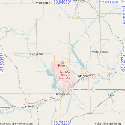
Riley GPS coordinates[2]
39° 17' 56.004" North, 96° 49' 51.024" West
| Map corner | latitude | longitude |
|---|---|---|
| Upper-left | 39.84089°, | -97.53397° |
| Center: | 39.29889°, | -96.83084° |
| Lower-right: | 38.75266°, | -96.12772° |
| Map W x H: | 121×121 km | = 75.2×75.2mi |
| max Lat: | 71.29058° ⇑52.3% North |
| Riley: | 39.29889° |
| min Lat: | ⇓47.7% South 19.06759° |
| min Long | Riley | max Long |
| -171.73463° | -96.83084° | -66.98998° |
| W 24.7%⇐ | ⇒75.3% E |
Elevation
Elevation of Riley is 394 m = 1293 ft, and this is 99.2 m = 325 ft above average elevation for this country.
| Max E: |
3189 m = 10463 ft | 16.7% |
| Riley | 394 m 1293 ft | |
| Avg. | 294.8 m = 967 ft | |
Min E: |
-60 m = -197 ft | 83.3% |
See also: United States elevation on elevation.city.
Geographical zone
Riley is located in North temperate zone (between Tropic of Cancer and the Arctic Circle). Distance of this Northern Tropic circle is 1763.7 km =1095.9 mi to South.| Distance of | km | miles | from Riley |
|---|---|---|---|
| North Pole | 5637.4 | 3502.9 | to North |
| Arctic Circle | 3031.5 | 1883.7 | to North |
| Tropic Cancer | 1763.7 | 1095.9 | to South |
| Equator | 4369.6 | 2715.1 | to South |


Nearby cities:
15 places around Riley: (largest is in red/bold)
• Blue Rapids
45.1 km =28 mi,  19°
19°
• Chapman
39.9 km =24.8 mi,  204°
204°
• Clay Center
26.7 km =16.6 mi,  288°
288°
• Clifton
48.7 km =30.3 mi,  307°
307°
• Fort Riley North
21 km =13 mi,  176°
176°
• Grandview Plaza
30.2 km =18.8 mi,  173°
173°
• Junction City
30.1 km =18.7 mi, 180°
• Manhattan
25.7 km =16 mi,  119°
119°
• Milford
16.1 km =10 mi,  205°
205°
• Ogden
23.5 km =14.6 mi,  152°
152°
• Saint George
37.3 km =23.2 mi,  108°
108°
• Wakefield
17.8 km =11.1 mi,  237°
237°
• Wamego
46.5 km =28.9 mi,  103°
103°
• Waterville
44.2 km =27.5 mi,  9°
9°
• Westmoreland
37.4 km =23.2 mi,  73°
73°
Sources, notices
• [Note1] Compared only with cities in United States existing in our database
• [Src1] Map data: © OpenStreetMap contributors (CC-BY-SA)
• [Src2] Other city data from geonames.org with taken over terms of usage.
• [Src3] Geographical zone / Annual Mean Temperature by Robert A. Rohde @ Wikipedia
