Burnside geodata
Burnside (Kentucky) is a populated place; located in United States in America/New_York (GMT-4) time zone. With population of 843 people, there are 17421 cities with bigger population in this country. Compared to other cities in United States, 66.2% of cities are located further ↑North; 57% of cities are located further ←West and 64.3% of cities have lower elevation than Burnside. Note1


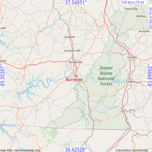
Burnside GPS coordinates[2]
36° 59' 20.292" North, 84° 35' 59.784" West
| Map corner | latitude | longitude |
|---|---|---|
| Upper-left | 37.54851°, | -85.30307° |
| Center: | 36.98897°, | -84.59994° |
| Lower-right: | 36.42528°, | -83.89682° |
| Map W x H: | 124.9×124.9 km | = 77.6×77.6mi |
| max Lat: | 71.29058° ⇑66.2% North |
| Burnside: | 36.98897° |
| min Lat: | ⇓33.8% South 19.06759° |
| min Long | Burnside | max Long |
| -171.73463° | -84.59994° | -66.98998° |
| W 57%⇐ | ⇒43% E |
Elevation
Elevation of Burnside is 259 m = 850 ft, and this is 35.8 m = 117 ft below average elevation for this country.
| Max E: |
3189 m = 10463 ft | 35.7% |
| Avg. | 294.8 m = 967 ft | |
| Burnside | 259 m = 850 ft | |
Min E: |
-60 m = -197 ft | 64.3% |
See also: United States elevation on elevation.city.
Geographical zone
Burnside is located in North temperate zone (between Tropic of Cancer and the Arctic Circle). Distance of this Northern Tropic circle is 1506.9 km =936.3 mi to South.| Distance of | km | miles | from Burnside |
|---|---|---|---|
| North Pole | 5894.3 | 3662.5 | to North |
| Arctic Circle | 3288.4 | 2043.3 | to North |
| Tropic Cancer | 1506.9 | 936.3 | to South |
| Equator | 4112.8 | 2555.6 | to South |


Nearby cities:
15 places around Burnside: (largest is in red/bold)
• Corbin
44.9 km =27.9 mi,  95°
95°
• Ferguson
8.6 km =5.3 mi,  0°
0°
• Jamestown
41.1 km =25.5 mi,  269°
269°
• Liberty
47.4 km =29.5 mi,  320°
320°
• Monticello
28.4 km =17.6 mi,  231°
231°
• Mount Vernon
46.5 km =28.9 mi,  29°
29°
• North Corbin
45.1 km =28 mi,  94°
94°
• Pine Knot
40.2 km =25 mi,  159°
159°
• Russell Springs
44 km =27.3 mi,  279°
279°
• Salem
35.4 km =22 mi, 284°
• Science Hill
21.1 km =13.1 mi,  351°
351°
• Somerset
11.5 km =7.1 mi,  358°
358°
• Stearns
34 km =21.1 mi, 161°
• Whitley City
31.7 km =19.7 mi, 158°
• Williamsburg
47.7 km =29.6 mi,  124°
124°
Sources, notices
• [Note1] Compared only with cities in United States existing in our database
• [Src1] Map data: © OpenStreetMap contributors (CC-BY-SA)
• [Src2] Other city data from geonames.org with taken over terms of usage.
• [Src3] Geographical zone / Annual Mean Temperature by Robert A. Rohde @ Wikipedia
