Ferguson geodata
Ferguson (Kentucky) is a populated place; located in United States in America/New_York (GMT-4) time zone. With population of 943 people, there are 16684 cities with bigger population in this country. Compared to other cities in United States, 65.9% of cities are located further ↑North; 57% of cities are located further ←West and 69.9% of cities have lower elevation than Ferguson. Note1


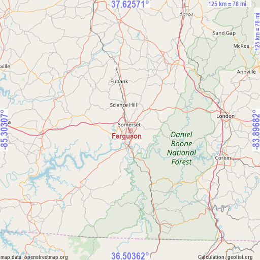
Ferguson GPS coordinates[2]
37° 4' 0.264" North, 84° 35' 59.784" West
| Map corner | latitude | longitude |
|---|---|---|
| Upper-left | 37.62571°, | -85.30307° |
| Center: | 37.06674°, | -84.59994° |
| Lower-right: | 36.50362°, | -83.89682° |
| Map W x H: | 124.8×124.8 km | = 77.5×77.5mi |
| max Lat: | 71.29058° ⇑65.9% North |
| Ferguson: | 37.06674° |
| min Lat: | ⇓34.1% South 19.06759° |
| min Long | Ferguson | max Long |
| -171.73463° | -84.59994° | -66.98998° |
| W 57%⇐ | ⇒43% E |
Elevation
Elevation of Ferguson is 285 m = 935 ft, and this is 9.8 m = 32 ft below average elevation for this country.
| Max E: |
3189 m = 10463 ft | 30.1% |
| Avg. | 294.8 m = 967 ft | |
| Ferguson | 285 m = 935 ft | |
Min E: |
-60 m = -197 ft | 69.9% |
See also: United States elevation on elevation.city.
Geographical zone
Ferguson is located in North temperate zone (between Tropic of Cancer and the Arctic Circle). Distance of this Northern Tropic circle is 1515.5 km =941.7 mi to South.| Distance of | km | miles | from Ferguson |
|---|---|---|---|
| North Pole | 5885.6 | 3657.1 | to North |
| Arctic Circle | 3279.7 | 2037.9 | to North |
| Tropic Cancer | 1515.5 | 941.7 | to South |
| Equator | 4121.4 | 2560.9 | to South |


Nearby cities:
15 places around Ferguson: (largest is in red/bold)
• Brodhead
41 km =25.5 mi,  23°
23°
• Burnside
8.6 km =5.3 mi,  180°
180°
• Crab Orchard
45 km =28 mi,  10°
10°
• East Bernstadt
44.9 km =27.9 mi,  72°
72°
• Jamestown
42.1 km =26.2 mi,  257°
257°
• Liberty
41.1 km =25.5 mi,  312°
312°
• London
46.3 km =28.8 mi,  81°
81°
• Monticello
34.4 km =21.4 mi,  220°
220°
• Mount Vernon
39.2 km =24.4 mi,  35°
35°
• Russell Springs
43.4 km =27 mi,  268°
268°
• Salem
34.2 km =21.3 mi, 270°
• Science Hill
12.7 km =7.9 mi,  345°
345°
• Somerset
2.8 km =1.7 mi, 352°
• Stearns
42.3 km =26.3 mi,  165°
165°
• Whitley City
39.9 km =24.8 mi,  163°
163°
Sources, notices
• [Note1] Compared only with cities in United States existing in our database
• [Src1] Map data: © OpenStreetMap contributors (CC-BY-SA)
• [Src2] Other city data from geonames.org with taken over terms of usage.
• [Src3] Geographical zone / Annual Mean Temperature by Robert A. Rohde @ Wikipedia
