Whitley City geodata
Whitley City (Kentucky) is a seat of a second-order administrative division; located in United States in America/New_York (GMT-4) time zone. With population of 1,170 people, there are 15292 cities with bigger population in this country. Compared to other cities in United States, 67.2% of cities are located further ↑North; 57.5% of cities are located further ←West and 84.5% of cities have lower elevation than Whitley City. Note1


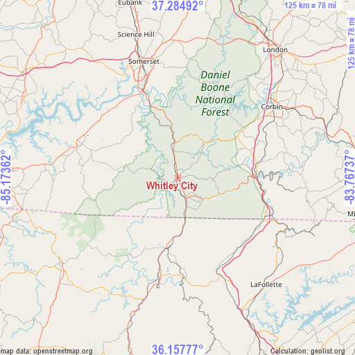
Whitley City GPS coordinates[2]
36° 43' 24.276" North, 84° 28' 13.764" West
| Map corner | latitude | longitude |
|---|---|---|
| Upper-left | 37.28492°, | -85.17362° |
| Center: | 36.72341°, | -84.47049° |
| Lower-right: | 36.15777°, | -83.76737° |
| Map W x H: | 125.3×125.3 km | = 77.9×77.9mi |
| max Lat: | 71.29058° ⇑67.2% North |
| Whitley City: | 36.72341° |
| min Lat: | ⇓32.8% South 19.06759° |
| min Long | Whitley City | max Long |
| -171.73463° | -84.47049° | -66.98998° |
| W 57.5%⇐ | ⇒42.5% E |
Elevation
Elevation of Whitley City is 413 m = 1355 ft, and this is 118.2 m = 388 ft above average elevation for this country.
| Max E: |
3189 m = 10463 ft | 15.5% |
| Whitley City | 413 m 1355 ft | |
| Avg. | 294.8 m = 967 ft | |
Min E: |
-60 m = -197 ft | 84.5% |
See also: United States elevation on elevation.city.
Geographical zone
Whitley City is located in North temperate zone (between Tropic of Cancer and the Arctic Circle). Distance of this Northern Tropic circle is 1477.3 km =918 mi to South.| Distance of | km | miles | from Whitley City |
|---|---|---|---|
| North Pole | 5923.8 | 3680.9 | to North |
| Arctic Circle | 3317.9 | 2061.6 | to North |
| Tropic Cancer | 1477.3 | 918 | to South |
| Equator | 4083.3 | 2537.2 | to South |


Nearby cities:
15 places around Whitley City: (largest is in red/bold)
• Burnside
31.7 km =19.7 mi,  338°
338°
• Corbin
41.6 km =25.8 mi,  53°
53°
• Ferguson
39.9 km =24.8 mi, 343°
• Helenwood
33.3 km =20.7 mi,  191°
191°
• Huntsville
34.9 km =21.7 mi,  182°
182°
• Jellico
34.2 km =21.3 mi,  116°
116°
• LaFollette
49.1 km =30.5 mi,  140°
140°
• Monticello
35.7 km =22.2 mi,  289°
289°
• North Corbin
42.7 km =26.5 mi, 51°
• Oneida
25.3 km =15.7 mi, 188°
• Pine Knot
8.5 km =5.3 mi,  160°
160°
• Somerset
42.7 km =26.5 mi, 343°
• Stearns
2.8 km =1.7 mi, 192°
• Williamsburg
27.8 km =17.3 mi,  85°
85°
• Winfield
18.7 km =11.6 mi,  174°
174°
Sources, notices
• [Note1] Compared only with cities in United States existing in our database
• [Src1] Map data: © OpenStreetMap contributors (CC-BY-SA)
• [Src2] Other city data from geonames.org with taken over terms of usage.
• [Src3] Geographical zone / Annual Mean Temperature by Robert A. Rohde @ Wikipedia
