Somerset geodata
Somerset (Kentucky) is a seat of a second-order administrative division; located in United States in America/New_York (GMT-4) time zone. With population of 11,439 people, there are 4043 cities with bigger population in this country. Compared to other cities in United States, 65.7% of cities are located further ↑North; 57% of cities are located further ←West and 72.4% of cities have lower elevation than Somerset. Note1


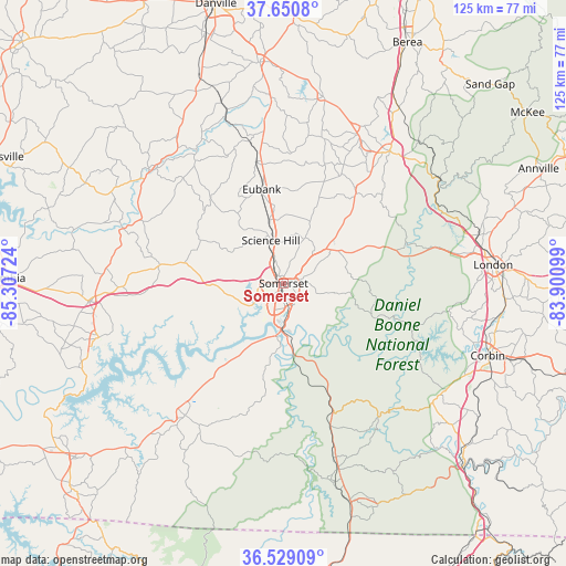
Somerset GPS coordinates[2]
37° 5' 31.272" North, 84° 36' 14.796" West
| Map corner | latitude | longitude |
|---|---|---|
| Upper-left | 37.6508°, | -85.30724° |
| Center: | 37.09202°, | -84.60411° |
| Lower-right: | 36.52909°, | -83.90099° |
| Map W x H: | 124.7×124.7 km | = 77.5×77.5mi |
| max Lat: | 71.29058° ⇑65.7% North |
| Somerset: | 37.09202° |
| min Lat: | ⇓34.3% South 19.06759° |
| min Long | Somerset | max Long |
| -171.73463° | -84.60411° | -66.98998° |
| W 57%⇐ | ⇒43% E |
Elevation
Elevation of Somerset is 298 m = 978 ft, and this is 3.2 m = 10 ft above average elevation for this country.
| Max E: |
3189 m = 10463 ft | 27.6% |
| Somerset | 298 m 978 ft | |
| Avg. | 294.8 m = 967 ft | |
Min E: |
-60 m = -197 ft | 72.4% |
See also: United States elevation on elevation.city.
Geographical zone
Somerset is located in North temperate zone (between Tropic of Cancer and the Arctic Circle). Distance of this Northern Tropic circle is 1518.3 km =943.4 mi to South.| Distance of | km | miles | from Somerset |
|---|---|---|---|
| North Pole | 5882.8 | 3655.4 | to North |
| Arctic Circle | 3276.9 | 2036.2 | to North |
| Tropic Cancer | 1518.3 | 943.4 | to South |
| Equator | 4124.2 | 2562.7 | to South |


Nearby cities:
15 places around Somerset: (largest is in red/bold)
• Brodhead
38.6 km =24 mi,  25°
25°
• Burnside
11.5 km =7.1 mi,  178°
178°
• Crab Orchard
42.3 km =26.3 mi,  11°
11°
• East Bernstadt
44.5 km =27.7 mi,  75°
75°
• Ferguson
2.8 km =1.7 mi,  172°
172°
• Jamestown
42.4 km =26.3 mi,  253°
253°
• Liberty
38.9 km =24.2 mi,  310°
310°
• London
46.4 km =28.8 mi, 84°
• Monticello
36.4 km =22.6 mi,  216°
216°
• Mount Vernon
37.2 km =23.1 mi,  38°
38°
• Russell Springs
43.2 km =26.8 mi,  264°
264°
• Salem
33.9 km =21.1 mi,  265°
265°
• Science Hill
9.9 km =6.2 mi,  343°
343°
• Stearns
45.1 km =28 mi, 165°
• Whitley City
42.7 km =26.5 mi,  163°
163°
Sources, notices
• [Note1] Compared only with cities in United States existing in our database
• [Src1] Map data: © OpenStreetMap contributors (CC-BY-SA)
• [Src2] Other city data from geonames.org with taken over terms of usage.
• [Src3] Geographical zone / Annual Mean Temperature by Robert A. Rohde @ Wikipedia
