Richmond geodata
Richmond (Kentucky) is a seat of a second-order administrative division; located in United States in America/New_York (GMT-4) time zone. With population of 33,533 people, there are 1477 cities with bigger population in this country. Compared to other cities in United States, 63% of cities are located further ↑North; 58.3% of cities are located further ←West and 71.5% of cities have lower elevation than Richmond. Note1


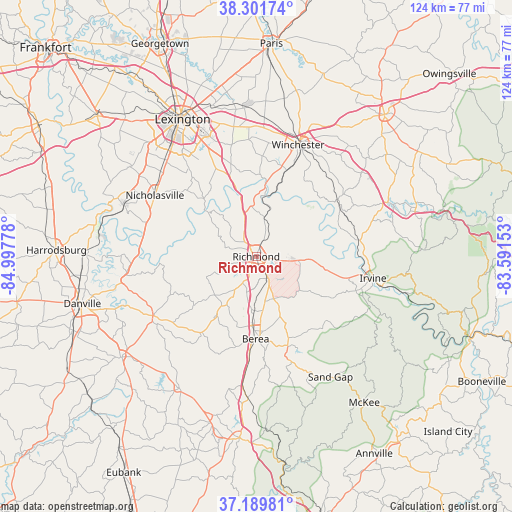
Richmond GPS coordinates[2]
37° 44' 52.296" North, 84° 17' 40.74" West
| Map corner | latitude | longitude |
|---|---|---|
| Upper-left | 38.30174°, | -84.99778° |
| Center: | 37.74786°, | -84.29465° |
| Lower-right: | 37.18981°, | -83.59153° |
| Map W x H: | 123.6×123.6 km | = 76.8×76.8mi |
| max Lat: | 71.29058° ⇑63% North |
| Richmond: | 37.74786° |
| min Lat: | ⇓37% South 19.06759° |
| min Long | Richmond | max Long |
| -171.73463° | -84.29465° | -66.98998° |
| W 58.3%⇐ | ⇒41.7% E |
Elevation
Elevation of Richmond is 293 m = 961 ft, and this is 1.8 m = 6 ft below average elevation for this country.
| Max E: |
3189 m = 10463 ft | 28.5% |
| Avg. | 294.8 m = 967 ft | |
| Richmond | 293 m = 961 ft | |
Min E: |
-60 m = -197 ft | 71.5% |
See also: United States elevation on elevation.city.
Geographical zone
Richmond is located in North temperate zone (between Tropic of Cancer and the Arctic Circle). Distance of this Northern Tropic circle is 1591.2 km =988.7 mi to South.| Distance of | km | miles | from Richmond |
|---|---|---|---|
| North Pole | 5809.9 | 3610.1 | to North |
| Arctic Circle | 3204 | 1990.9 | to North |
| Tropic Cancer | 1591.2 | 988.7 | to South |
| Equator | 4197.2 | 2608 | to South |


Nearby cities:
15 places around Richmond: (largest is in red/bold)
• Berea
19.9 km =12.4 mi,  180°
180°
• Brodhead
39.6 km =24.6 mi,  195°
195°
• Clay City
35.3 km =21.9 mi,  69°
69°
• Crab Orchard
36.6 km =22.7 mi,  210°
210°
• Irvine
28.7 km =17.8 mi,  100°
100°
• Lancaster
28.7 km =17.8 mi,  240°
240°
• Lexington
31.2 km =19.4 mi,  329°
329°
• Lexington-Fayette
36.5 km =22.7 mi,  336°
336°
• Monticello
35.2 km =21.9 mi,  320°
320°
• Mount Vernon
35.5 km =22.1 mi, 330°
• Nicholasville
28.6 km =17.8 mi,  301°
301°
• Ravenna
30.9 km =19.2 mi, 103°
• Stanton
39.9 km =24.8 mi, 74°
• Wilmore
34.6 km =21.5 mi,  291°
291°
• Winchester
28.8 km =17.9 mi,  20°
20°
Sources, notices
• [Note1] Compared only with cities in United States existing in our database
• [Src1] Map data: © OpenStreetMap contributors (CC-BY-SA)
• [Src2] Other city data from geonames.org with taken over terms of usage.
• [Src3] Geographical zone / Annual Mean Temperature by Robert A. Rohde @ Wikipedia
