Dawson Springs geodata
Dawson Springs (Kentucky) is a populated place; located in United States in America/Chicago (GMT-5) time zone. With population of 2,737 people, there are 10111 cities with bigger population in this country. Compared to other cities in United States, 65.4% of cities are located further ↑North; 51.4% of cities are located further →East and 64.7% of cities have higher elevation than Dawson Springs. Note1


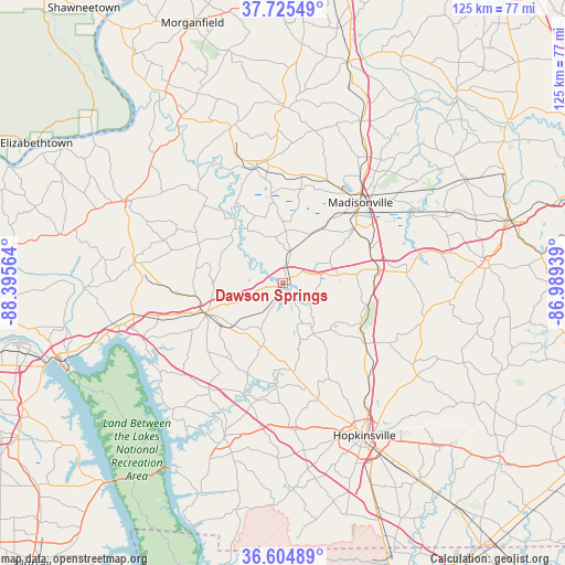
Dawson Springs GPS coordinates[2]
37° 10' 2.172" North, 87° 41' 33.036" West
| Map corner | latitude | longitude |
|---|---|---|
| Upper-left | 37.72549°, | -88.39564° |
| Center: | 37.16727°, | -87.69251° |
| Lower-right: | 36.60489°, | -86.98939° |
| Map W x H: | 124.6×124.6 km | = 77.4×77.4mi |
| max Lat: | 71.29058° ⇑65.4% North |
| Dawson Springs: | 37.16727° |
| min Lat: | ⇓34.6% South 19.06759° |
| min Long | Dawson Springs | max Long |
| -171.73463° | -87.69251° | -66.98998° |
| W 48.6%⇐ | ⇒51.4% E |
Elevation
Elevation of Dawson Springs is 130 m = 427 ft, and this is 164.8 m = 541 ft below average elevation for this country.
| Max E: |
3189 m = 10463 ft | 64.7% |
| Avg. | 294.8 m = 967 ft | |
| Dawson Springs | 130 m = 427 ft | |
Min E: |
-60 m = -197 ft | 35.3% |
See also: United States elevation on elevation.city.
Geographical zone
Dawson Springs is located in North temperate zone (between Tropic of Cancer and the Arctic Circle). Distance of this Northern Tropic circle is 1526.7 km =948.6 mi to South.| Distance of | km | miles | from Dawson Springs |
|---|---|---|---|
| North Pole | 5874.4 | 3650.2 | to North |
| Arctic Circle | 3268.6 | 2031 | to North |
| Tropic Cancer | 1526.7 | 948.6 | to South |
| Equator | 4132.6 | 2567.9 | to South |


Nearby cities:
15 places around Dawson Springs: (largest is in red/bold)
• Cadiz
35.9 km =22.3 mi,  200°
200°
• Clay
36.2 km =22.5 mi,  341°
341°
• Crofton
22.7 km =14.1 mi,  125°
125°
• Dixon
39 km =24.2 mi,  0°
0°
• Earlington
19.9 km =12.4 mi,  53°
53°
• Eddyville
35.3 km =21.9 mi,  256°
256°
• Hanson
33.5 km =20.8 mi,  33°
33°
• Hopkinsville
38 km =23.6 mi,  151°
151°
• Madisonville
24.8 km =15.4 mi,  43°
43°
• Marion
39 km =24.2 mi,  298°
298°
• Mortons Gap
20.7 km =12.9 mi,  68°
68°
• Nortonville
21.4 km =13.3 mi,  82°
82°
• Princeton
18 km =11.2 mi,  248°
248°
• Providence
26.3 km =16.3 mi,  346°
346°
• White Plains
27.4 km =17 mi,  86°
86°
Sources, notices
• [Note1] Compared only with cities in United States existing in our database
• [Src1] Map data: © OpenStreetMap contributors (CC-BY-SA)
• [Src2] Other city data from geonames.org with taken over terms of usage.
• [Src3] Geographical zone / Annual Mean Temperature by Robert A. Rohde @ Wikipedia
