Hopkinsville geodata
Hopkinsville (Kentucky) is a seat of a second-order administrative division; located in United States in America/Chicago (GMT-5) time zone. With population of 32,205 people, there are 1552 cities with bigger population in this country. Compared to other cities in United States, 66.7% of cities are located further ↑North; 50.8% of cities are located further →East and 59.1% of cities have higher elevation than Hopkinsville. Note1


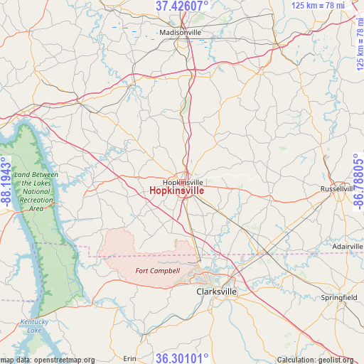
Hopkinsville GPS coordinates[2]
36° 51' 56.196" North, 87° 29' 28.212" West
| Map corner | latitude | longitude |
|---|---|---|
| Upper-left | 37.42607°, | -88.1943° |
| Center: | 36.86561°, | -87.49117° |
| Lower-right: | 36.30101°, | -86.78805° |
| Map W x H: | 125.1×125.1 km | = 77.7×77.7mi |
| max Lat: | 71.29058° ⇑66.7% North |
| Hopkinsville: | 36.86561° |
| min Lat: | ⇓33.3% South 19.06759° |
| min Long | Hopkinsville | max Long |
| -171.73463° | -87.49117° | -66.98998° |
| W 49.2%⇐ | ⇒50.8% E |
Elevation
Elevation of Hopkinsville is 159 m = 522 ft, and this is 135.8 m = 446 ft below average elevation for this country.
| Max E: |
3189 m = 10463 ft | 59.1% |
| Avg. | 294.8 m = 967 ft | |
| Hopkinsville | 159 m = 522 ft | |
Min E: |
-60 m = -197 ft | 40.9% |
See also: United States elevation on elevation.city.
Geographical zone
Hopkinsville is located in North temperate zone (between Tropic of Cancer and the Arctic Circle). Distance of this Northern Tropic circle is 1493.2 km =927.8 mi to South.| Distance of | km | miles | from Hopkinsville |
|---|---|---|---|
| North Pole | 5908 | 3671.1 | to North |
| Arctic Circle | 3302.1 | 2051.8 | to North |
| Tropic Cancer | 1493.2 | 927.8 | to South |
| Equator | 4099.1 | 2547.1 | to South |


Nearby cities:
15 places around Hopkinsville: (largest is in red/bold)
• Cadiz
30.6 km =19 mi,  269°
269°
• Clarksville
39.1 km =24.3 mi,  162°
162°
• Crofton
20.3 km =12.6 mi,  1°
1°
• Dawson Springs
38 km =23.6 mi,  331°
331°
• Earlington
45.5 km =28.3 mi,  357°
357°
• Elkton
30.6 km =19 mi,  101°
101°
• Fort Campbell North
23.7 km =14.7 mi,  173°
173°
• Greenville
46.5 km =28.9 mi,  36°
36°
• Guthrie
37.7 km =23.4 mi,  129°
129°
• Mortons Gap
41.3 km =25.7 mi, 1°
• Nortonville
36.3 km =22.6 mi,  5°
5°
• Oak Grove
22.7 km =14.1 mi, 169°
• Pembroke
15.7 km =9.8 mi, 129°
• Princeton
44 km =27.3 mi,  307°
307°
• White Plains
36.6 km =22.7 mi,  15°
15°
Sources, notices
• [Note1] Compared only with cities in United States existing in our database
• [Src1] Map data: © OpenStreetMap contributors (CC-BY-SA)
• [Src2] Other city data from geonames.org with taken over terms of usage.
• [Src3] Geographical zone / Annual Mean Temperature by Robert A. Rohde @ Wikipedia
