Cadiz geodata
Cadiz (Kentucky) is a seat of a second-order administrative division; located in United States in America/Chicago (GMT-5) time zone. With population of 2,626 people, there are 10338 cities with bigger population in this country. Compared to other cities in United States, 66.7% of cities are located further ↑North; 52.1% of cities are located further →East and 63.3% of cities have higher elevation than Cadiz. Note1


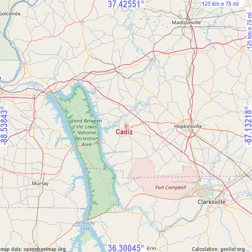
Cadiz GPS coordinates[2]
36° 51' 54.18" North, 87° 50' 7.08" West
| Map corner | latitude | longitude |
|---|---|---|
| Upper-left | 37.42551°, | -88.53843° |
| Center: | 36.86505°, | -87.8353° |
| Lower-right: | 36.30045°, | -87.13218° |
| Map W x H: | 125.1×125.1 km | = 77.7×77.7mi |
| max Lat: | 71.29058° ⇑66.7% North |
| Cadiz: | 36.86505° |
| min Lat: | ⇓33.3% South 19.06759° |
| min Long | Cadiz | max Long |
| -171.73463° | -87.8353° | -66.98998° |
| W 47.9%⇐ | ⇒52.1% E |
Elevation
Elevation of Cadiz is 137 m = 449 ft, and this is 157.8 m = 518 ft below average elevation for this country.
| Max E: |
3189 m = 10463 ft | 63.3% |
| Avg. | 294.8 m = 967 ft | |
| Cadiz | 137 m = 449 ft | |
Min E: |
-60 m = -197 ft | 36.7% |
See also: United States elevation on elevation.city.
Geographical zone
Cadiz is located in North temperate zone (between Tropic of Cancer and the Arctic Circle). Distance of this Northern Tropic circle is 1493.1 km =927.8 mi to South.| Distance of | km | miles | from Cadiz |
|---|---|---|---|
| North Pole | 5908.1 | 3671.1 | to North |
| Arctic Circle | 3302.2 | 2051.9 | to North |
| Tropic Cancer | 1493.1 | 927.8 | to South |
| Equator | 4099 | 2547 | to South |


Nearby cities:
15 places around Cadiz: (largest is in red/bold)
• Benton
45.8 km =28.5 mi,  268°
268°
• Calvert City
49.4 km =30.7 mi,  292°
292°
• Crofton
37.2 km =23.1 mi,  56°
56°
• Dawson Springs
35.9 km =22.3 mi,  20°
20°
• Dover
41.9 km =26 mi,  180°
180°
• Eddyville
33.5 km =20.8 mi,  319°
319°
• Fort Campbell North
40.8 km =25.4 mi,  125°
125°
• Hardin
42.4 km =26.3 mi,  254°
254°
• Hopkinsville
30.6 km =19 mi,  89°
89°
• Kuttawa
34.1 km =21.2 mi,  309°
309°
• Murray
51.3 km =31.9 mi,  236°
236°
• Nortonville
49.7 km =30.9 mi,  43°
43°
• Oak Grove
41.4 km =25.7 mi,  122°
122°
• Pembroke
43.8 km =27.2 mi,  103°
103°
• Princeton
27.5 km =17.1 mi,  351°
351°
Sources, notices
• [Note1] Compared only with cities in United States existing in our database
• [Src1] Map data: © OpenStreetMap contributors (CC-BY-SA)
• [Src2] Other city data from geonames.org with taken over terms of usage.
• [Src3] Geographical zone / Annual Mean Temperature by Robert A. Rohde @ Wikipedia
