East Bernstadt geodata
East Bernstadt (Kentucky) is a populated place; located in United States in America/New_York (GMT-4) time zone. With population of 716 people, there are 18538 cities with bigger population in this country. Compared to other cities in United States, 65.3% of cities are located further ↑North; 59% of cities are located further ←West and 81.1% of cities have lower elevation than East Bernstadt. Note1


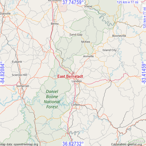
East Bernstadt GPS coordinates[2]
37° 11' 22.308" North, 84° 7' 3.756" West
| Map corner | latitude | longitude |
|---|---|---|
| Upper-left | 37.74759°, | -84.82084° |
| Center: | 37.18953°, | -84.11771° |
| Lower-right: | 36.62732°, | -83.41459° |
| Map W x H: | 124.6×124.6 km | = 77.4×77.4mi |
| max Lat: | 71.29058° ⇑65.3% North |
| East Bernstadt: | 37.18953° |
| min Lat: | ⇓34.7% South 19.06759° |
| min Long | East Bernstadt | max Long |
| -171.73463° | -84.11771° | -66.98998° |
| W 59%⇐ | ⇒41% E |
Elevation
Elevation of East Bernstadt is 366 m = 1201 ft, and this is 71.2 m = 234 ft above average elevation for this country.
| Max E: |
3189 m = 10463 ft | 18.9% |
| East Bernstadt | 366 m 1201 ft | |
| Avg. | 294.8 m = 967 ft | |
Min E: |
-60 m = -197 ft | 81.1% |
See also: United States elevation on elevation.city.
Geographical zone
East Bernstadt is located in North temperate zone (between Tropic of Cancer and the Arctic Circle). Distance of this Northern Tropic circle is 1529.2 km =950.2 mi to South.| Distance of | km | miles | from East Bernstadt |
|---|---|---|---|
| North Pole | 5872 | 3648.7 | to North |
| Arctic Circle | 3266.1 | 2029.5 | to North |
| Tropic Cancer | 1529.2 | 950.2 | to South |
| Equator | 4135.1 | 2569.4 | to South |


Nearby cities:
15 places around East Bernstadt: (largest is in red/bold)
• Annville
19.4 km =12.1 mi,  42°
42°
• Artemus
46.6 km =29 mi,  148°
148°
• Barbourville
41.3 km =25.7 mi, 150°
• Berea
45 km =28 mi,  339°
339°
• Brodhead
35.4 km =22 mi,  312°
312°
• Corbin
26.8 km =16.7 mi,  176°
176°
• Crab Orchard
46 km =28.6 mi, 311°
• Ferguson
44.9 km =27.9 mi,  252°
252°
• London
7.4 km =4.6 mi,  155°
155°
• Manchester
31.8 km =19.8 mi,  97°
97°
• McKee
28.8 km =17.9 mi,  21°
21°
• Mount Vernon
26.8 km =16.7 mi, 312°
• North Corbin
25.5 km =15.8 mi, 175°
• Science Hill
45.9 km =28.5 mi,  268°
268°
• Somerset
44.5 km =27.7 mi,  255°
255°
Sources, notices
• [Note1] Compared only with cities in United States existing in our database
• [Src1] Map data: © OpenStreetMap contributors (CC-BY-SA)
• [Src2] Other city data from geonames.org with taken over terms of usage.
• [Src3] Geographical zone / Annual Mean Temperature by Robert A. Rohde @ Wikipedia
