Fordsville geodata
Fordsville (Kentucky) is a populated place; located in United States in America/Chicago (GMT-5) time zone. With population of 530 people, there are 20501 cities with bigger population in this country. Compared to other cities in United States, 63.5% of cities are located further ↑North; 51% of cities are located further ←West and 60.1% of cities have higher elevation than Fordsville. Note1


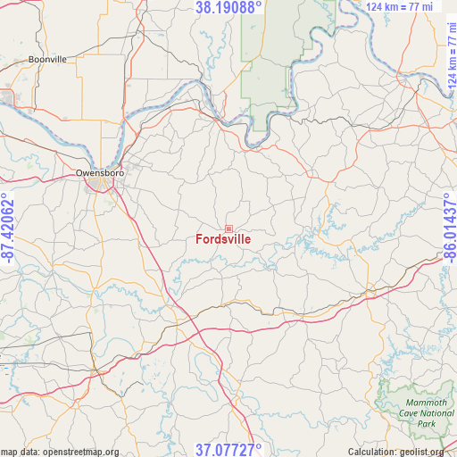
Fordsville GPS coordinates[2]
37° 38' 10.176" North, 86° 43' 2.964" West
| Map corner | latitude | longitude |
|---|---|---|
| Upper-left | 38.19088°, | -87.42062° |
| Center: | 37.63616°, | -86.71749° |
| Lower-right: | 37.07727°, | -86.01437° |
| Map W x H: | 123.8×123.8 km | = 76.9×76.9mi |
| max Lat: | 71.29058° ⇑63.5% North |
| Fordsville: | 37.63616° |
| min Lat: | ⇓36.5% South 19.06759° |
| min Long | Fordsville | max Long |
| -171.73463° | -86.71749° | -66.98998° |
| W 51%⇐ | ⇒49% E |
Elevation
Elevation of Fordsville is 154 m = 505 ft, and this is 140.8 m = 462 ft below average elevation for this country.
| Max E: |
3189 m = 10463 ft | 60.1% |
| Avg. | 294.8 m = 967 ft | |
| Fordsville | 154 m = 505 ft | |
Min E: |
-60 m = -197 ft | 39.9% |
See also: United States elevation on elevation.city.
Geographical zone
Fordsville is located in North temperate zone (between Tropic of Cancer and the Arctic Circle). Distance of this Northern Tropic circle is 1578.8 km =981 mi to South.| Distance of | km | miles | from Fordsville |
|---|---|---|---|
| North Pole | 5822.3 | 3617.8 | to North |
| Arctic Circle | 3216.4 | 1998.6 | to North |
| Tropic Cancer | 1578.8 | 981 | to South |
| Equator | 4184.7 | 2600.3 | to South |


Nearby cities:
15 places around Fordsville: (largest is in red/bold)
• Beaver Dam
29.5 km =18.3 mi,  208°
208°
• Caneyville
31 km =19.3 mi,  139°
139°
• Cannelton
30.7 km =19.1 mi,  355°
355°
• Cloverport
23.2 km =14.4 mi,  18°
18°
• Hardinsburg
27.7 km =17.2 mi,  54°
54°
• Hartford
26.6 km =16.5 mi,  219°
219°
• Hawesville
29.5 km =18.3 mi,  353°
353°
• Knottsville
22.3 km =13.9 mi,  312°
312°
• Lewisport
37.2 km =23.1 mi,  334°
334°
• Livermore
39.8 km =24.7 mi,  246°
246°
• Masonville
28.3 km =17.6 mi,  278°
278°
• Oak Grove
32.6 km =20.3 mi,  185°
185°
• Owensboro
38.1 km =23.7 mi,  293°
293°
• Tell City
35.3 km =21.9 mi, 352°
• Whitesville
14.5 km =9 mi, 291°
Sources, notices
• [Note1] Compared only with cities in United States existing in our database
• [Src1] Map data: © OpenStreetMap contributors (CC-BY-SA)
• [Src2] Other city data from geonames.org with taken over terms of usage.
• [Src3] Geographical zone / Annual Mean Temperature by Robert A. Rohde @ Wikipedia
