Caneyville geodata
Caneyville (Kentucky) is a populated place; located in United States in America/Chicago (GMT-5) time zone. With population of 620 people, there are 19469 cities with bigger population in this country. Compared to other cities in United States, 64.3% of cities are located further ↑North; 51.6% of cities are located further ←West and 60.7% of cities have higher elevation than Caneyville. Note1


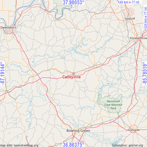
Caneyville GPS coordinates[2]
37° 25' 27.192" North, 86° 29' 17.916" West
| Map corner | latitude | longitude |
|---|---|---|
| Upper-left | 37.98053°, | -87.19144° |
| Center: | 37.42422°, | -86.48831° |
| Lower-right: | 36.86375°, | -85.78519° |
| Map W x H: | 124.2×124.2 km | = 77.2×77.2mi |
| max Lat: | 71.29058° ⇑64.3% North |
| Caneyville: | 37.42422° |
| min Lat: | ⇓35.7% South 19.06759° |
| min Long | Caneyville | max Long |
| -171.73463° | -86.48831° | -66.98998° |
| W 51.6%⇐ | ⇒48.4% E |
Elevation
Elevation of Caneyville is 151 m = 495 ft, and this is 143.8 m = 472 ft below average elevation for this country.
| Max E: |
3189 m = 10463 ft | 60.7% |
| Avg. | 294.8 m = 967 ft | |
| Caneyville | 151 m = 495 ft | |
Min E: |
-60 m = -197 ft | 39.3% |
See also: United States elevation on elevation.city.
Geographical zone
Caneyville is located in North temperate zone (between Tropic of Cancer and the Arctic Circle). Distance of this Northern Tropic circle is 1555.3 km =966.4 mi to South.| Distance of | km | miles | from Caneyville |
|---|---|---|---|
| North Pole | 5845.9 | 3632.5 | to North |
| Arctic Circle | 3240 | 2013.2 | to North |
| Tropic Cancer | 1555.3 | 966.4 | to South |
| Equator | 4161.2 | 2585.6 | to South |


Nearby cities:
15 places around Caneyville: (largest is in red/bold)
• Beaver Dam
34.3 km =21.3 mi,  265°
265°
• Bowling Green
48.4 km =30.1 mi,  175°
175°
• Brownsville
32.3 km =20.1 mi,  142°
142°
• Clarkson
24.9 km =15.5 mi,  71°
71°
• Cloverport
47.2 km =29.3 mi,  344°
344°
• Fordsville
31 km =19.3 mi,  319°
319°
• Hardinsburg
39.6 km =24.6 mi,  3°
3°
• Hartford
37.3 km =23.2 mi, 274°
• Knottsville
53.2 km =33.1 mi, 316°
• Leitchfield
18.3 km =11.4 mi, 70°
• Morgantown
28 km =17.4 mi,  218°
218°
• Oak Grove
25.2 km =15.7 mi,  249°
249°
• Smiths Grove
48.2 km =30 mi,  148°
148°
• Upton
52.7 km =32.7 mi,  85°
85°
• Whitesville
44.4 km =27.6 mi,  310°
310°
Sources, notices
• [Note1] Compared only with cities in United States existing in our database
• [Src1] Map data: © OpenStreetMap contributors (CC-BY-SA)
• [Src2] Other city data from geonames.org with taken over terms of usage.
• [Src3] Geographical zone / Annual Mean Temperature by Robert A. Rohde @ Wikipedia
