Jackson geodata
Jackson (Kentucky) is a seat of a second-order administrative division; located in United States in America/New_York (GMT-4) time zone. With population of 2,152 people, there are 11459 cities with bigger population in this country. Compared to other cities in United States, 63.9% of cities are located further ↑North; 60.9% of cities are located further ←West and 60.1% of cities have lower elevation than Jackson. Note1


Jackson GPS coordinates[2]
37° 33' 11.34" North, 83° 23' 0.636" West
| Map corner | latitude | longitude |
|---|---|---|
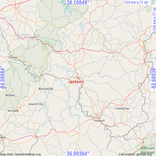
| Upper-left | 38.10849°, | -84.08664° |
| Center: | 37.55315°, | -83.38351° |
| Lower-right: | 36.99364°, | -82.68039° |
| Map W x H: | 124×124 km | = 77.1×77.1mi |
| max Lat: | 71.29058° ⇑63.9% North |
| Jackson: | 37.55315° |
| min Lat: | ⇓36.1% South 19.06759° |
| min Long | Jackson | max Long |
| -171.73463° | -83.38351° | -66.98998° |
| W 60.9%⇐ | ⇒39.1% E |
Elevation
Elevation of Jackson is 240 m = 787 ft, and this is 54.8 m = 180 ft below average elevation for this country.
| Max E: |
3189 m = 10463 ft | 39.9% |
| Avg. | 294.8 m = 967 ft | |
| Jackson | 240 m = 787 ft | |
Min E: |
-60 m = -197 ft | 60.1% |
See also: United States elevation on elevation.city.
Geographical zone
Jackson is located in North temperate zone (between Tropic of Cancer and the Arctic Circle). Distance of this Northern Tropic circle is 1569.6 km =975.3 mi to South.| Distance of | km | miles | from Jackson |
|---|---|---|---|
| North Pole | 5831.5 | 3623.5 | to North |
| Arctic Circle | 3225.7 | 2004.4 | to North |
| Tropic Cancer | 1569.6 | 975.3 | to South |
| Equator | 4175.5 | 2594.5 | to South |


Nearby cities:
15 places around Jackson: (largest is in red/bold)
• Beattyville
28.6 km =17.8 mi,  274°
274°
• Booneville
27.1 km =16.8 mi,  251°
251°
• Campton
24.8 km =15.4 mi,  324°
324°
• Elkfork
50.8 km =31.6 mi,  25°
25°
• Frenchburg
49.1 km =30.5 mi,  334°
334°
• Hazard
37.7 km =23.4 mi,  153°
153°
• Hindman
43 km =26.7 mi,  124°
124°
• Hyden
43.6 km =27.1 mi,  178°
178°
• Irvine
54.5 km =33.9 mi,  287°
287°
• Pippa Passes
51.1 km =31.8 mi, 118°
• Prestonsburg
55.3 km =34.4 mi,  76°
76°
• Ravenna
52.2 km =32.4 mi, 286°
• Salyersville
35.5 km =22.1 mi,  51°
51°
• Stanton
52.9 km =32.9 mi,  307°
307°
• West Liberty
42.4 km =26.3 mi,  14°
14°
Sources, notices
• [Note1] Compared only with cities in United States existing in our database
• [Src1] Map data: © OpenStreetMap contributors (CC-BY-SA)
• [Src2] Other city data from geonames.org with taken over terms of usage.
• [Src3] Geographical zone / Annual Mean Temperature by Robert A. Rohde @ Wikipedia
