West Liberty geodata
West Liberty (Kentucky) is a seat of a second-order administrative division; located in United States in America/New_York (GMT-4) time zone. With population of 3,330 people, there are 9095 cities with bigger population in this country. Compared to other cities in United States, 62.1% of cities are located further ↑North; 61.3% of cities are located further ←West and 61.7% of cities have lower elevation than West Liberty. Note1


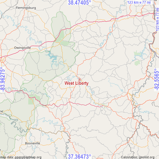
West Liberty GPS coordinates[2]
37° 55' 17.328" North, 83° 15' 34.632" West
| Map corner | latitude | longitude |
|---|---|---|
| Upper-left | 38.47405°, | -83.96275° |
| Center: | 37.92148°, | -83.25962° |
| Lower-right: | 37.36473°, | -82.5565° |
| Map W x H: | 123.3×123.3 km | = 76.6×76.6mi |
| max Lat: | 71.29058° ⇑62.1% North |
| West Liberty: | 37.92148° |
| min Lat: | ⇓37.9% South 19.06759° |
| min Long | West Liberty | max Long |
| -171.73463° | -83.25962° | -66.98998° |
| W 61.3%⇐ | ⇒38.7% E |
Elevation
Elevation of West Liberty is 247 m = 810 ft, and this is 47.8 m = 157 ft below average elevation for this country.
| Max E: |
3189 m = 10463 ft | 38.3% |
| Avg. | 294.8 m = 967 ft | |
| West Liberty | 247 m = 810 ft | |
Min E: |
-60 m = -197 ft | 61.7% |
See also: United States elevation on elevation.city.
Geographical zone
West Liberty is located in North temperate zone (between Tropic of Cancer and the Arctic Circle). Distance of this Northern Tropic circle is 1610.6 km =1000.8 mi to South.| Distance of | km | miles | from West Liberty |
|---|---|---|---|
| North Pole | 5790.6 | 3598.1 | to North |
| Arctic Circle | 3184.7 | 1978.9 | to North |
| Tropic Cancer | 1610.6 | 1000.8 | to South |
| Equator | 4216.5 | 2620 | to South |


Nearby cities:
15 places around West Liberty: (largest is in red/bold)
• Auxier
48.6 km =30.2 mi,  114°
114°
• Campton
32.7 km =20.3 mi,  230°
230°
• Elkfork
12.1 km =7.5 mi,  66°
66°
• Frenchburg
32.3 km =20.1 mi,  275°
275°
• Grayson
53.2 km =33.1 mi,  30°
30°
• Jackson
42.4 km =26.3 mi,  194°
194°
• Jeffersonville
51.4 km =31.9 mi, 276°
• Morehead
32.9 km =20.4 mi,  332°
332°
• Olive Hill
42.8 km =26.6 mi,  10°
10°
• Owingsville
50.7 km =31.5 mi,  299°
299°
• Paintsville
41.5 km =25.8 mi, 106°
• Prestonsburg
51.5 km =32 mi,  123°
123°
• Salyersville
25.2 km =15.7 mi,  138°
138°
• Sandy Hook
21.7 km =13.5 mi, 32°
• Van Lear
47.1 km =29.3 mi, 110°
Sources, notices
• [Note1] Compared only with cities in United States existing in our database
• [Src1] Map data: © OpenStreetMap contributors (CC-BY-SA)
• [Src2] Other city data from geonames.org with taken over terms of usage.
• [Src3] Geographical zone / Annual Mean Temperature by Robert A. Rohde @ Wikipedia
