Van Lear geodata
Van Lear (Kentucky) is a populated place; located in United States in America/New_York (GMT-4) time zone. With population of 1,079 people, there are 15794 cities with bigger population in this country. Compared to other cities in United States, 62.8% of cities are located further ↑North; 62.7% of cities are located further ←West and 51.4% of cities have higher elevation than Van Lear. Note1


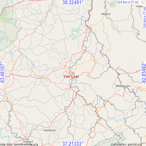
Van Lear GPS coordinates[2]
37° 46' 16.356" North, 82° 45' 28.584" West
| Map corner | latitude | longitude |
|---|---|---|
| Upper-left | 38.32491°, | -83.46107° |
| Center: | 37.77121°, | -82.75794° |
| Lower-right: | 37.21333°, | -82.05482° |
| Map W x H: | 123.6×123.6 km | = 76.8×76.8mi |
| max Lat: | 71.29058° ⇑62.8% North |
| Van Lear: | 37.77121° |
| min Lat: | ⇓37.2% South 19.06759° |
| min Long | Van Lear | max Long |
| -171.73463° | -82.75794° | -66.98998° |
| W 62.7%⇐ | ⇒37.3% E |
Elevation
Elevation of Van Lear is 193 m = 633 ft, and this is 101.8 m = 334 ft below average elevation for this country.
| Max E: |
3189 m = 10463 ft | 51.4% |
| Avg. | 294.8 m = 967 ft | |
| Van Lear | 193 m = 633 ft | |
Min E: |
-60 m = -197 ft | 48.6% |
See also: United States elevation on elevation.city.
Geographical zone
Van Lear is located in North temperate zone (between Tropic of Cancer and the Arctic Circle). Distance of this Northern Tropic circle is 1593.8 km =990.3 mi to South.| Distance of | km | miles | from Van Lear |
|---|---|---|---|
| North Pole | 5807.3 | 3608.5 | to North |
| Arctic Circle | 3201.4 | 1989.3 | to North |
| Tropic Cancer | 1593.8 | 990.3 | to South |
| Equator | 4199.8 | 2609.6 | to South |


Nearby cities:
15 places around Van Lear: (largest is in red/bold)
• Auxier
3.8 km =2.4 mi,  180°
180°
• Betsy Layne
26.8 km =16.7 mi,  155°
155°
• Chattaroy
42.6 km =26.5 mi,  100°
100°
• Coal Run Village
33.6 km =20.9 mi,  148°
148°
• Elkfork
39.3 km =24.4 mi,  303°
303°
• Fort Gay
40.9 km =25.4 mi,  20°
20°
• Inez
22 km =13.7 mi,  61°
61°
• Louisa
40.5 km =25.2 mi, 19°
• Martin
22.1 km =13.7 mi, 178°
• Paintsville
6.5 km =4 mi,  318°
318°
• Pikeville
38.7 km =24 mi, 147°
• Prestonsburg
11.8 km =7.3 mi,  185°
185°
• Salyersville
27.4 km =17 mi,  265°
265°
• South Williamson
43.1 km =26.8 mi, 104°
• Williamson
43.6 km =27.1 mi, 104°
Sources, notices
• [Note1] Compared only with cities in United States existing in our database
• [Src1] Map data: © OpenStreetMap contributors (CC-BY-SA)
• [Src2] Other city data from geonames.org with taken over terms of usage.
• [Src3] Geographical zone / Annual Mean Temperature by Robert A. Rohde @ Wikipedia
