Inez geodata
Inez (Kentucky) is a seat of a second-order administrative division; located in United States in America/New_York (GMT-4) time zone. With population of 684 people, there are 18841 cities with bigger population in this country. Compared to other cities in United States, 62.3% of cities are located further ↑North; 63.6% of cities are located further ←West and 50% of cities have lower elevation than Inez. Note1


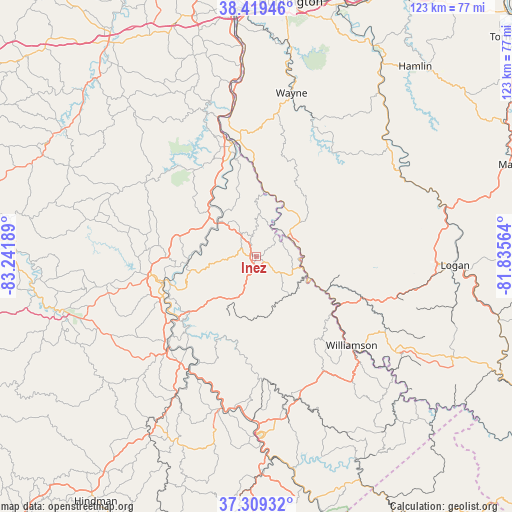
Inez GPS coordinates[2]
37° 51' 59.328" North, 82° 32' 19.536" West
| Map corner | latitude | longitude |
|---|---|---|
| Upper-left | 38.41946°, | -83.24189° |
| Center: | 37.86648°, | -82.53876° |
| Lower-right: | 37.30932°, | -81.83564° |
| Map W x H: | 123.4×123.4 km | = 76.7×76.7mi |
| max Lat: | 71.29058° ⇑62.3% North |
| Inez: | 37.86648° |
| min Lat: | ⇓37.7% South 19.06759° |
| min Long | Inez | max Long |
| -171.73463° | -82.53876° | -66.98998° |
| W 63.6%⇐ | ⇒36.4% E |
Elevation
Elevation of Inez is 198 m = 650 ft, and this is 96.8 m = 318 ft below average elevation for this country.
| Max E: |
3189 m = 10463 ft | 50% |
| Avg. | 294.8 m = 967 ft | |
| Inez | 198 m = 650 ft | |
Min E: |
-60 m = -197 ft | 50% |
See also: United States elevation on elevation.city.
Geographical zone
Inez is located in North temperate zone (between Tropic of Cancer and the Arctic Circle). Distance of this Northern Tropic circle is 1604.4 km =996.9 mi to South.| Distance of | km | miles | from Inez |
|---|---|---|---|
| North Pole | 5796.7 | 3601.9 | to North |
| Arctic Circle | 3190.8 | 1982.7 | to North |
| Tropic Cancer | 1604.4 | 996.9 | to South |
| Equator | 4210.4 | 2616.2 | to South |


Nearby cities:
15 places around Inez: (largest is in red/bold)
• Auxier
24.1 km =15 mi,  233°
233°
• Betsy Layne
36 km =22.4 mi,  193°
193°
• Chattaroy
29 km =18 mi,  128°
128°
• Coal Run Village
39.3 km =24.4 mi,  182°
182°
• Delbarton
35.7 km =22.2 mi,  119°
119°
• Fort Gay
28.2 km =17.5 mi,  349°
349°
• Harts
40.3 km =25 mi,  62°
62°
• Louisa
28.1 km =17.5 mi, 348°
• Martin
37.7 km =23.4 mi,  209°
209°
• Paintsville
24.3 km =15.1 mi,  256°
256°
• Prestonsburg
30.3 km =18.8 mi,  222°
222°
• South Williamson
31.1 km =19.3 mi, 133°
• Van Lear
22 km =13.7 mi,  241°
241°
• Wayne
40.4 km =25.1 mi,  12°
12°
• Williamson
31.4 km =19.5 mi, 132°
Sources, notices
• [Note1] Compared only with cities in United States existing in our database
• [Src1] Map data: © OpenStreetMap contributors (CC-BY-SA)
• [Src2] Other city data from geonames.org with taken over terms of usage.
• [Src3] Geographical zone / Annual Mean Temperature by Robert A. Rohde @ Wikipedia
