West Point geodata
West Point (Kentucky) is a populated place; located in United States in America/New_York (GMT-4) time zone. With population of 868 people, there are 17212 cities with bigger population in this country. Compared to other cities in United States, 61.6% of cities are located further ↑North; 53.1% of cities are located further ←West and 64% of cities have higher elevation than West Point. Note1


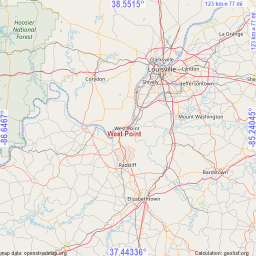
West Point GPS coordinates[2]
37° 59' 58.272" North, 85° 56' 36.852" West
| Map corner | latitude | longitude |
|---|---|---|
| Upper-left | 38.5515°, | -86.6467° |
| Center: | 37.99952°, | -85.94357° |
| Lower-right: | 37.44336°, | -85.24045° |
| Map W x H: | 123.2×123.2 km | = 76.6×76.6mi |
| max Lat: | 71.29058° ⇑61.6% North |
| West Point: | 37.99952° |
| min Lat: | ⇓38.4% South 19.06759° |
| min Long | West Point | max Long |
| -171.73463° | -85.94357° | -66.98998° |
| W 53.1%⇐ | ⇒46.9% E |
Elevation
Elevation of West Point is 133 m = 436 ft, and this is 161.8 m = 531 ft below average elevation for this country.
| Max E: |
3189 m = 10463 ft | 64% |
| Avg. | 294.8 m = 967 ft | |
| West Point | 133 m = 436 ft | |
Min E: |
-60 m = -197 ft | 36% |
See also: United States elevation on elevation.city.
Geographical zone
West Point is located in North temperate zone (between Tropic of Cancer and the Arctic Circle). Distance of this Northern Tropic circle is 1619.2 km =1006.1 mi to South.| Distance of | km | miles | from West Point |
|---|---|---|---|
| North Pole | 5781.9 | 3592.7 | to North |
| Arctic Circle | 3176 | 1973.5 | to North |
| Tropic Cancer | 1619.2 | 1006.1 | to South |
| Equator | 4225.2 | 2625.4 | to South |


Nearby cities:
15 places around West Point: (largest is in red/bold)
• Brandenburg
19.8 km =12.3 mi,  269°
269°
• Brooks
21.6 km =13.4 mi,  71°
71°
• Doe Valley
15.9 km =9.9 mi,  252°
252°
• Fairdale
20 km =12.4 mi,  54°
54°
• Fort Knox
12.2 km =7.6 mi,  188°
188°
• Heritage Creek
24 km =14.9 mi, 54°
• Hillview
23.9 km =14.9 mi, 70°
• Hollyvilla
20.3 km =12.6 mi,  58°
58°
• Muldraugh
8.1 km =5 mi,  211°
211°
• Pleasure Ridge Park
17.9 km =11.1 mi,  24°
24°
• Radcliff
17.7 km =11 mi,  181°
181°
• Saint Dennis
22.7 km =14.1 mi, 22°
• Shepherdsville
20 km =12.4 mi,  93°
93°
• Valley Station
14 km =8.7 mi,  27°
27°
• Vine Grove
21.3 km =13.2 mi, 188°
Sources, notices
• [Note1] Compared only with cities in United States existing in our database
• [Src1] Map data: © OpenStreetMap contributors (CC-BY-SA)
• [Src2] Other city data from geonames.org with taken over terms of usage.
• [Src3] Geographical zone / Annual Mean Temperature by Robert A. Rohde @ Wikipedia
