Vine Grove geodata
Vine Grove (Kentucky) is a populated place; located in United States in America/New_York (GMT-4) time zone. With population of 5,760 people, there are 6565 cities with bigger population in this country. Compared to other cities in United States, 62.6% of cities are located further ↑North; 52.9% of cities are located further ←West and 53% of cities have lower elevation than Vine Grove. Note1


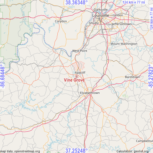
Vine Grove GPS coordinates[2]
37° 48' 36.252" North, 85° 58' 52.86" West
| Map corner | latitude | longitude |
|---|---|---|
| Upper-left | 38.36348°, | -86.68448° |
| Center: | 37.81007°, | -85.98135° |
| Lower-right: | 37.25248°, | -85.27823° |
| Map W x H: | 123.5×123.5 km | = 76.7×76.7mi |
| max Lat: | 71.29058° ⇑62.6% North |
| Vine Grove: | 37.81007° |
| min Lat: | ⇓37.4% South 19.06759° |
| min Long | Vine Grove | max Long |
| -171.73463° | -85.98135° | -66.98998° |
| W 52.9%⇐ | ⇒47.1% E |
Elevation
Elevation of Vine Grove is 210 m = 689 ft, and this is 84.8 m = 278 ft below average elevation for this country.
| Max E: |
3189 m = 10463 ft | 47% |
| Avg. | 294.8 m = 967 ft | |
| Vine Grove | 210 m = 689 ft | |
Min E: |
-60 m = -197 ft | 53% |
See also: United States elevation on elevation.city.
Geographical zone
Vine Grove is located in North temperate zone (between Tropic of Cancer and the Arctic Circle). Distance of this Northern Tropic circle is 1598.2 km =993.1 mi to South.| Distance of | km | miles | from Vine Grove |
|---|---|---|---|
| North Pole | 5803 | 3605.8 | to North |
| Arctic Circle | 3197.1 | 1986.6 | to North |
| Tropic Cancer | 1598.2 | 993.1 | to South |
| Equator | 4204.1 | 2612.3 | to South |


Nearby cities:
15 places around Vine Grove: (largest is in red/bold)
• Brandenburg
26.7 km =16.6 mi,  321°
321°
• Brooks
36.7 km =22.8 mi,  40°
40°
• Cecilia
16.2 km =10.1 mi,  172°
172°
• Doe Valley
20.2 km =12.6 mi, 323°
• Elizabethtown
16.8 km =10.4 mi,  140°
140°
• Fort Knox
9.1 km =5.7 mi,  9°
9°
• Hodgenville
33.8 km =21 mi, 141°
• Hollyvilla
37.7 km =23.4 mi,  33°
33°
• Irvington
27.7 km =17.2 mi,  286°
286°
• Lebanon Junction
22.1 km =13.7 mi,  82°
82°
• Muldraugh
14.1 km =8.8 mi,  356°
356°
• Radcliff
4.4 km =2.7 mi, 40°
• Shepherdsville
30.6 km =19 mi,  49°
49°
• Valley Station
34.9 km =21.7 mi,  16°
16°
• West Point
21.3 km =13.2 mi, 8°
Sources, notices
• [Note1] Compared only with cities in United States existing in our database
• [Src1] Map data: © OpenStreetMap contributors (CC-BY-SA)
• [Src2] Other city data from geonames.org with taken over terms of usage.
• [Src3] Geographical zone / Annual Mean Temperature by Robert A. Rohde @ Wikipedia
