Fort Knox geodata
Fort Knox (Kentucky) is a populated place; located in United States in America/New_York (GMT-4) time zone. With population of 10,124 people, there are 4428 cities with bigger population in this country. Compared to other cities in United States, 62.2% of cities are located further ↑North; 53% of cities are located further ←West and 56.4% of cities have lower elevation than Fort Knox. Note1


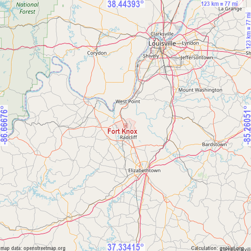
Fort Knox GPS coordinates[2]
37° 53' 28.068" North, 85° 57' 49.068" West
| Map corner | latitude | longitude |
|---|---|---|
| Upper-left | 38.44393°, | -86.66676° |
| Center: | 37.89113°, | -85.96363° |
| Lower-right: | 37.33415°, | -85.26051° |
| Map W x H: | 123.4×123.4 km | = 76.7×76.7mi |
| max Lat: | 71.29058° ⇑62.2% North |
| Fort Knox: | 37.89113° |
| min Lat: | ⇓37.8% South 19.06759° |
| min Long | Fort Knox | max Long |
| -171.73463° | -85.96363° | -66.98998° |
| W 53%⇐ | ⇒47% E |
Elevation
Elevation of Fort Knox is 224 m = 735 ft, and this is 70.8 m = 232 ft below average elevation for this country.
| Max E: |
3189 m = 10463 ft | 43.6% |
| Avg. | 294.8 m = 967 ft | |
| Fort Knox | 224 m = 735 ft | |
Min E: |
-60 m = -197 ft | 56.4% |
See also: United States elevation on elevation.city.
Geographical zone
Fort Knox is located in North temperate zone (between Tropic of Cancer and the Arctic Circle). Distance of this Northern Tropic circle is 1607.2 km =998.7 mi to South.| Distance of | km | miles | from Fort Knox |
|---|---|---|---|
| North Pole | 5794 | 3600.2 | to North |
| Arctic Circle | 3188.1 | 1981 | to North |
| Tropic Cancer | 1607.2 | 998.7 | to South |
| Equator | 4213.1 | 2617.9 | to South |


Nearby cities:
15 places around Fort Knox: (largest is in red/bold)
• Brandenburg
21.7 km =13.5 mi,  303°
303°
• Brooks
29.2 km =18.1 mi,  49°
49°
• Cecilia
25.1 km =15.6 mi,  178°
178°
• Doe Valley
15.3 km =9.5 mi, 298°
• Elizabethtown
23.8 km =14.8 mi,  157°
157°
• Hollyvilla
29.5 km =18.3 mi,  40°
40°
• Irvington
28.1 km =17.5 mi,  267°
267°
• Lebanon Junction
21.3 km =13.2 mi,  107°
107°
• Muldraugh
5.7 km =3.5 mi,  334°
334°
• Pleasure Ridge Park
29.7 km =18.5 mi,  18°
18°
• Radcliff
5.8 km =3.6 mi,  167°
167°
• Shepherdsville
24.3 km =15.1 mi,  63°
63°
• Valley Station
25.8 km =16 mi, 18°
• Vine Grove
9.1 km =5.7 mi,  189°
189°
• West Point
12.2 km =7.6 mi,  8°
8°
Sources, notices
• [Note1] Compared only with cities in United States existing in our database
• [Src1] Map data: © OpenStreetMap contributors (CC-BY-SA)
• [Src2] Other city data from geonames.org with taken over terms of usage.
• [Src3] Geographical zone / Annual Mean Temperature by Robert A. Rohde @ Wikipedia
