Bastrop geodata
Bastrop (Louisiana) is a seat of a second-order administrative division; located in United States in America/Chicago (GMT-5) time zone. With population of 10,713 people, there are 4262 cities with bigger population in this country. Compared to other cities in United States, 86% of cities are located further ↑North; 63.9% of cities are located further →East and 82.3% of cities have higher elevation than Bastrop. Note1


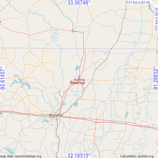
Bastrop GPS coordinates[2]
32° 46' 41.808" North, 91° 54' 41.184" West
| Map corner | latitude | longitude |
|---|---|---|
| Upper-left | 33.36748°, | -92.61457° |
| Center: | 32.77828°, | -91.91144° |
| Lower-right: | 32.18515°, | -91.20832° |
| Map W x H: | 131.5×131.5 km | = 81.7×81.7mi |
| max Lat: | 71.29058° ⇑86% North |
| Bastrop: | 32.77828° |
| min Lat: | ⇓14% South 19.06759° |
| min Long | Bastrop | max Long |
| -171.73463° | -91.91144° | -66.98998° |
| W 36.1%⇐ | ⇒63.9% E |
Elevation
Elevation of Bastrop is 37 m = 121 ft, and this is 257.8 m = 846 ft below average elevation for this country.
| Max E: |
3189 m = 10463 ft | 82.3% |
| Avg. | 294.8 m = 967 ft | |
| Bastrop | 37 m = 121 ft | |
Min E: |
-60 m = -197 ft | 17.7% |
See also: United States elevation on elevation.city.
Geographical zone
Bastrop is located in North temperate zone (between Tropic of Cancer and the Arctic Circle). Distance of this Northern Tropic circle is 1038.7 km =645.4 mi to South.| Distance of | km | miles | from Bastrop |
|---|---|---|---|
| North Pole | 6362.5 | 3953.5 | to North |
| Arctic Circle | 3756.6 | 2334.2 | to North |
| Tropic Cancer | 1038.7 | 645.4 | to South |
| Equator | 3644.6 | 2264.6 | to South |


Nearby cities:
15 places around Bastrop: (largest is in red/bold)
• Brownsville
39.6 km =24.6 mi,  215°
215°
• Claiborne
39.2 km =24.4 mi, 221°
• Crossett
39.2 km =24.4 mi,  353°
353°
• Huttig
38.5 km =23.9 mi,  318°
318°
• Lakeshore
29.2 km =18.1 mi,  202°
202°
• Marion
33.8 km =21 mi,  293°
293°
• Mer Rouge
11.1 km =6.9 mi,  91°
91°
• Monroe
35.7 km =22.2 mi,  213°
213°
• Rayville
36.5 km =22.7 mi,  156°
156°
• Richwood
40.1 km =24.9 mi, 203°
• Start
32.8 km =20.4 mi,  171°
171°
• Sterlington
18.7 km =11.6 mi,  240°
240°
• Swartz
24.3 km =15.1 mi, 196°
• West Crossett
41.1 km =25.5 mi, 349°
• West Monroe
36.4 km =22.6 mi, 217°
Sources, notices
• [Note1] Compared only with cities in United States existing in our database
• [Src1] Map data: © OpenStreetMap contributors (CC-BY-SA)
• [Src2] Other city data from geonames.org with taken over terms of usage.
• [Src3] Geographical zone / Annual Mean Temperature by Robert A. Rohde @ Wikipedia
