Monroe geodata
Monroe (Louisiana) is a seat of a second-order administrative division; located in United States in America/Chicago (GMT-5) time zone. With population of 49,598 people, there are 962 cities with bigger population in this country. Compared to other cities in United States, 87.1% of cities are located further ↑North; 64.4% of cities are located further →East and 85.1% of cities have higher elevation than Monroe. Note1


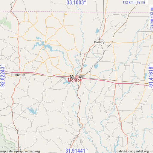
Monroe GPS coordinates[2]
32° 30' 33.516" North, 92° 7' 9.48" West
| Map corner | latitude | longitude |
|---|---|---|
| Upper-left | 33.1003°, | -92.82243° |
| Center: | 32.50931°, | -92.1193° |
| Lower-right: | 31.91441°, | -91.41618° |
| Map W x H: | 131.9×131.9 km | = 82×82mi |
| max Lat: | 71.29058° ⇑87.1% North |
| Monroe: | 32.50931° |
| min Lat: | ⇓12.9% South 19.06759° |
| min Long | Monroe | max Long |
| -171.73463° | -92.1193° | -66.98998° |
| W 35.6%⇐ | ⇒64.4% E |
Elevation
Elevation of Monroe is 28 m = 92 ft, and this is 266.8 m = 875 ft below average elevation for this country.
| Max E: |
3189 m = 10463 ft | 85.1% |
| Avg. | 294.8 m = 967 ft | |
| Monroe | 28 m = 92 ft | |
Min E: |
-60 m = -197 ft | 14.9% |
See also: Monroe elevation on elevation.city.
Geographical zone
Monroe is located in North temperate zone (between Tropic of Cancer and the Arctic Circle). Distance of this Northern Tropic circle is 1008.8 km =626.8 mi to South.| Distance of | km | miles | from Monroe |
|---|---|---|---|
| North Pole | 6392.4 | 3972.1 | to North |
| Arctic Circle | 3786.5 | 2352.8 | to North |
| Tropic Cancer | 1008.8 | 626.8 | to South |
| Equator | 3614.7 | 2246.1 | to South |


Nearby cities:
15 places around Monroe: (largest is in red/bold)
• Bastrop
35.7 km =22.2 mi,  33°
33°
• Bawcomville
6.2 km =3.9 mi,  226°
226°
• Brownsville
4.1 km =2.5 mi, 233°
• Calhoun
22.4 km =13.9 mi,  270°
270°
• Chatham
38.4 km =23.9 mi, 234°
• Choudrant
37.1 km =23.1 mi, 273°
• Claiborne
6.8 km =4.2 mi,  276°
276°
• Lakeshore
8.9 km =5.5 mi,  71°
71°
• Mangham
39.3 km =24.4 mi,  124°
124°
• Rayville
34.4 km =21.4 mi,  95°
95°
• Richwood
7.5 km =4.7 mi,  154°
154°
• Start
24.5 km =15.2 mi, 95°
• Sterlington
21 km =13 mi,  8°
8°
• Swartz
14.2 km =8.8 mi,  62°
62°
• West Monroe
2.8 km =1.7 mi,  290°
290°
Sources, notices
• [Note1] Compared only with cities in United States existing in our database
• [Src1] Map data: © OpenStreetMap contributors (CC-BY-SA)
• [Src2] Other city data from geonames.org with taken over terms of usage.
• [Src3] Geographical zone / Annual Mean Temperature by Robert A. Rohde @ Wikipedia
