Claiborne geodata
Claiborne (Louisiana) is a populated place; located in United States in America/Chicago (GMT-5) time zone. With population of 11,507 people, there are 4025 cities with bigger population in this country. Compared to other cities in United States, 87.1% of cities are located further ↑North; 64.6% of cities are located further →East and 78.8% of cities have higher elevation than Claiborne. Note1


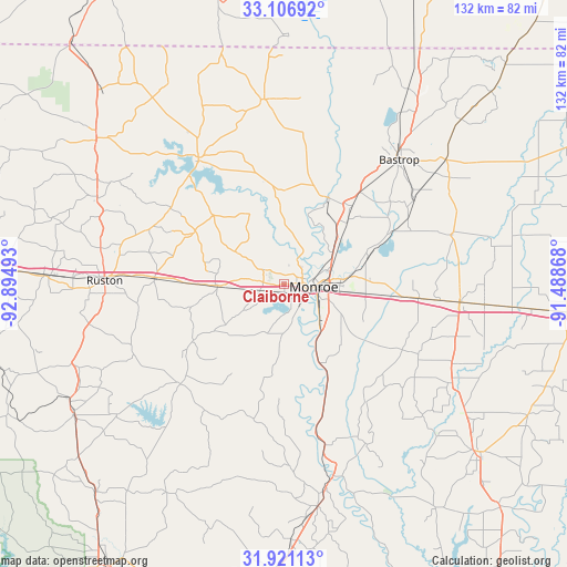
Claiborne GPS coordinates[2]
32° 30' 57.528" North, 92° 11' 30.48" West
| Map corner | latitude | longitude |
|---|---|---|
| Upper-left | 33.10692°, | -92.89493° |
| Center: | 32.51598°, | -92.1918° |
| Lower-right: | 31.92113°, | -91.48868° |
| Map W x H: | 131.8×131.8 km | = 81.9×81.9mi |
| max Lat: | 71.29058° ⇑87.1% North |
| Claiborne: | 32.51598° |
| min Lat: | ⇓12.9% South 19.06759° |
| min Long | Claiborne | max Long |
| -171.73463° | -92.1918° | -66.98998° |
| W 35.4%⇐ | ⇒64.6% E |
Elevation
Elevation of Claiborne is 52 m = 171 ft, and this is 242.8 m = 797 ft below average elevation for this country.
| Max E: |
3189 m = 10463 ft | 78.8% |
| Avg. | 294.8 m = 967 ft | |
| Claiborne | 52 m = 171 ft | |
Min E: |
-60 m = -197 ft | 21.2% |
See also: United States elevation on elevation.city.
Geographical zone
Claiborne is located in North temperate zone (between Tropic of Cancer and the Arctic Circle). Distance of this Northern Tropic circle is 1009.5 km =627.3 mi to South.| Distance of | km | miles | from Claiborne |
|---|---|---|---|
| North Pole | 6391.6 | 3971.6 | to North |
| Arctic Circle | 3785.7 | 2352.3 | to North |
| Tropic Cancer | 1009.5 | 627.3 | to South |
| Equator | 3615.4 | 2246.5 | to South |


Nearby cities:
15 places around Claiborne: (largest is in red/bold)
• Bastrop
39.2 km =24.4 mi,  41°
41°
• Bawcomville
5.6 km =3.5 mi,  155°
155°
• Brownsville
4.8 km =3 mi,  132°
132°
• Calhoun
15.6 km =9.7 mi,  268°
268°
• Chatham
33.7 km =20.9 mi,  226°
226°
• Choudrant
30.3 km =18.8 mi, 272°
• Farmerville
34.9 km =21.7 mi,  325°
325°
• Lakeshore
15.4 km =9.6 mi,  82°
82°
• Monroe
6.8 km =4.2 mi,  96°
96°
• Rayville
41.2 km =25.6 mi, 95°
• Richwood
12.5 km =7.8 mi, 126°
• Start
31.4 km =19.5 mi, 95°
• Sterlington
22.4 km =13.9 mi,  26°
26°
• Swartz
20.2 km =12.6 mi,  73°
73°
• West Monroe
4.1 km =2.5 mi,  86°
86°
Sources, notices
• [Note1] Compared only with cities in United States existing in our database
• [Src1] Map data: © OpenStreetMap contributors (CC-BY-SA)
• [Src2] Other city data from geonames.org with taken over terms of usage.
• [Src3] Geographical zone / Annual Mean Temperature by Robert A. Rohde @ Wikipedia
