Bunkie geodata
Bunkie (Louisiana) is a populated place; located in United States in America/Chicago (GMT-5) time zone. With population of 4,066 people, there are 8142 cities with bigger population in this country. Compared to other cities in United States, 90.8% of cities are located further ↑North; 64.5% of cities are located further →East and 87.4% of cities have higher elevation than Bunkie. Note1


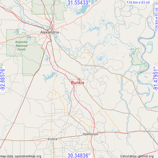
Bunkie GPS coordinates[2]
30° 57' 11.7" North, 92° 10' 57.468" West
| Map corner | latitude | longitude |
|---|---|---|
| Upper-left | 31.55433°, | -92.88576° |
| Center: | 30.95325°, | -92.18263° |
| Lower-right: | 30.34836°, | -91.47951° |
| Map W x H: | 134.1×134.1 km | = 83.3×83.3mi |
| max Lat: | 71.29058° ⇑90.8% North |
| Bunkie: | 30.95325° |
| min Lat: | ⇓9.2% South 19.06759° |
| min Long | Bunkie | max Long |
| -171.73463° | -92.18263° | -66.98998° |
| W 35.5%⇐ | ⇒64.5% E |
Elevation
Elevation of Bunkie is 22 m = 72 ft, and this is 272.8 m = 895 ft below average elevation for this country.
| Max E: |
3189 m = 10463 ft | 87.4% |
| Avg. | 294.8 m = 967 ft | |
| Bunkie | 22 m = 72 ft | |
Min E: |
-60 m = -197 ft | 12.6% |
See also: United States elevation on elevation.city.
Geographical zone
Bunkie is located in North temperate zone (between Tropic of Cancer and the Arctic Circle). Distance of this Northern Tropic circle is 835.8 km =519.3 mi to South.| Distance of | km | miles | from Bunkie |
|---|---|---|---|
| North Pole | 6565.4 | 4079.5 | to North |
| Arctic Circle | 3959.5 | 2460.3 | to North |
| Tropic Cancer | 835.8 | 519.3 | to South |
| Equator | 3441.7 | 2138.6 | to South |


Nearby cities:
15 places around Bunkie: (largest is in red/bold)
• Bordelonville
31.2 km =19.4 mi,  57°
57°
• Cheneyville
12.1 km =7.5 mi,  304°
304°
• Cottonport
12.8 km =8 mi,  74°
74°
• Fifth Ward
19.7 km =12.2 mi,  2°
2°
• Forest Hill
34.7 km =21.6 mi,  286°
286°
• Glenmora
38.5 km =23.9 mi,  273°
273°
• Hessmer
13.2 km =8.2 mi,  26°
26°
• Lecompte
26 km =16.2 mi,  307°
307°
• Mansura
17.3 km =10.7 mi,  47°
47°
• Marksville
22.4 km =13.9 mi, 29°
• Moreauville
21.7 km =13.5 mi, 65°
• Pine Prairie
29.9 km =18.6 mi,  230°
230°
• Simmesport
36.6 km =22.7 mi,  84°
84°
• Ville Platte
30.7 km =19.1 mi,  196°
196°
• Woodworth
36.9 km =22.9 mi, 305°
Sources, notices
• [Note1] Compared only with cities in United States existing in our database
• [Src1] Map data: © OpenStreetMap contributors (CC-BY-SA)
• [Src2] Other city data from geonames.org with taken over terms of usage.
• [Src3] Geographical zone / Annual Mean Temperature by Robert A. Rohde @ Wikipedia
