Haynesville geodata
Haynesville (Louisiana) is a populated place; located in United States in America/Chicago (GMT-5) time zone. With population of 2,174 people, there are 11407 cities with bigger population in this country. Compared to other cities in United States, 85.3% of cities are located further ↑North; 66.6% of cities are located further →East and 67.7% of cities have higher elevation than Haynesville. Note1


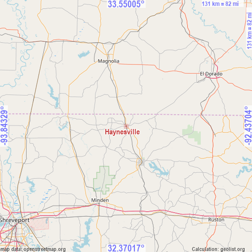
Haynesville GPS coordinates[2]
32° 57' 43.488" North, 93° 8' 24.576" West
| Map corner | latitude | longitude |
|---|---|---|
| Upper-left | 33.55005°, | -93.84329° |
| Center: | 32.96208°, | -93.14016° |
| Lower-right: | 32.37017°, | -92.43704° |
| Map W x H: | 131.2×131.2 km | = 81.5×81.5mi |
| max Lat: | 71.29058° ⇑85.3% North |
| Haynesville: | 32.96208° |
| min Lat: | ⇓14.7% South 19.06759° |
| min Long | Haynesville | max Long |
| -171.73463° | -93.14016° | -66.98998° |
| W 33.4%⇐ | ⇒66.6% E |
Elevation
Elevation of Haynesville is 114 m = 374 ft, and this is 180.8 m = 593 ft below average elevation for this country.
| Max E: |
3189 m = 10463 ft | 67.7% |
| Avg. | 294.8 m = 967 ft | |
| Haynesville | 114 m = 374 ft | |
Min E: |
-60 m = -197 ft | 32.3% |
See also: United States elevation on elevation.city.
Geographical zone
Haynesville is located in North temperate zone (between Tropic of Cancer and the Arctic Circle). Distance of this Northern Tropic circle is 1059.1 km =658.1 mi to South.| Distance of | km | miles | from Haynesville |
|---|---|---|---|
| North Pole | 6342 | 3940.7 | to North |
| Arctic Circle | 3736.1 | 2321.5 | to North |
| Tropic Cancer | 1059.1 | 658.1 | to South |
| Equator | 3665 | 2277.3 | to South |


Nearby cities:
15 places around Haynesville: (largest is in red/bold)
• Arcadia
50.3 km =31.3 mi,  155°
155°
• Bernice
47.6 km =29.6 mi,  109°
109°
• Cotton Valley
30.4 km =18.9 mi,  238°
238°
• Cullen
29 km =18 mi,  271°
271°
• Gibsland
47.2 km =29.3 mi,  170°
170°
• Homer
20.5 km =12.7 mi, 157°
• Junction City
39.1 km =24.3 mi,  81°
81°
• Junction City
39.2 km =24.4 mi, 81°
• Magnolia
35.1 km =21.8 mi,  344°
344°
• Minden
40.9 km =25.4 mi,  199°
199°
• Sarepta
29.8 km =18.5 mi,  255°
255°
• Sibley
49.2 km =30.6 mi, 197°
• Springhill
30.9 km =19.2 mi,  279°
279°
• Taylor
33.6 km =20.9 mi,  297°
297°
• Waldo
45.7 km =28.4 mi, 341°
Sources, notices
• [Note1] Compared only with cities in United States existing in our database
• [Src1] Map data: © OpenStreetMap contributors (CC-BY-SA)
• [Src2] Other city data from geonames.org with taken over terms of usage.
• [Src3] Geographical zone / Annual Mean Temperature by Robert A. Rohde @ Wikipedia
