Taylor geodata
Taylor (Arkansas) is a populated place; located in United States in America/Chicago (GMT-5) time zone. With population of 545 people, there are 20332 cities with bigger population in this country. Compared to other cities in United States, 84.8% of cities are located further ↑North; 67.4% of cities are located further →East and 74% of cities have higher elevation than Taylor. Note1


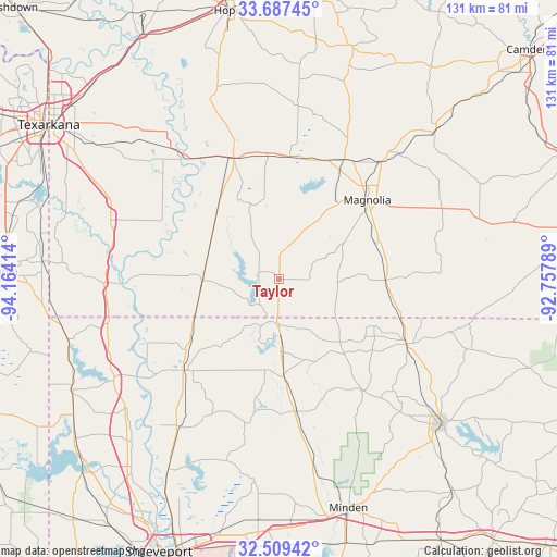
Taylor GPS coordinates[2]
33° 6' 1.476" North, 93° 27' 39.636" West
| Map corner | latitude | longitude |
|---|---|---|
| Upper-left | 33.68745°, | -94.16414° |
| Center: | 33.10041°, | -93.46101° |
| Lower-right: | 32.50942°, | -92.75789° |
| Map W x H: | 131×131 km | = 81.4×81.4mi |
| max Lat: | 71.29058° ⇑84.8% North |
| Taylor: | 33.10041° |
| min Lat: | ⇓15.2% South 19.06759° |
| min Long | Taylor | max Long |
| -171.73463° | -93.46101° | -66.98998° |
| W 32.6%⇐ | ⇒67.4% E |
Elevation
Elevation of Taylor is 77 m = 253 ft, and this is 217.8 m = 715 ft below average elevation for this country.
| Max E: |
3189 m = 10463 ft | 74% |
| Avg. | 294.8 m = 967 ft | |
| Taylor | 77 m = 253 ft | |
Min E: |
-60 m = -197 ft | 26% |
See also: United States elevation on elevation.city.
Geographical zone
Taylor is located in North temperate zone (between Tropic of Cancer and the Arctic Circle). Distance of this Northern Tropic circle is 1074.5 km =667.7 mi to South.| Distance of | km | miles | from Taylor |
|---|---|---|---|
| North Pole | 6326.6 | 3931.2 | to North |
| Arctic Circle | 3720.8 | 2312 | to North |
| Tropic Cancer | 1074.5 | 667.7 | to South |
| Equator | 3680.4 | 2286.9 | to South |


Nearby cities:
15 places around Taylor: (largest is in red/bold)
• Benton
52.2 km =32.4 mi,  210°
210°
• Bradley
18.1 km =11.2 mi,  269°
269°
• Cotton Valley
31.5 km =19.6 mi,  172°
172°
• Cullen
14.6 km =9.1 mi,  176°
176°
• Fouke
43.4 km =27 mi,  294°
294°
• Haynesville
33.6 km =20.9 mi,  117°
117°
• Homer
51.1 km =31.8 mi,  132°
132°
• Lewisville
30.7 km =19.1 mi,  339°
339°
• Magnolia
27.7 km =17.2 mi,  48°
48°
• Plain Dealing
30.9 km =19.2 mi,  225°
225°
• Sarepta
23.1 km =14.4 mi, 177°
• Springhill
10.5 km =6.5 mi, 182°
• Stamps
29.6 km =18.4 mi,  353°
353°
• Stephens
50.2 km =31.2 mi, 46°
• Waldo
31.9 km =19.8 mi,  28°
28°
Sources, notices
• [Note1] Compared only with cities in United States existing in our database
• [Src1] Map data: © OpenStreetMap contributors (CC-BY-SA)
• [Src2] Other city data from geonames.org with taken over terms of usage.
• [Src3] Geographical zone / Annual Mean Temperature by Robert A. Rohde @ Wikipedia
