Magnolia geodata
Magnolia (Arkansas) is a seat of a second-order administrative division; located in United States in America/Chicago (GMT-5) time zone. With population of 11,669 people, there are 3975 cities with bigger population in this country. Compared to other cities in United States, 84.1% of cities are located further ↑North; 66.8% of cities are located further →East and 69.1% of cities have higher elevation than Magnolia. Note1
Administrative division(s):
- Level 1: Arkansas
- Level 2: Columbia County
- Level 3: Township of Magnolia


Magnolia GPS coordinates[2]
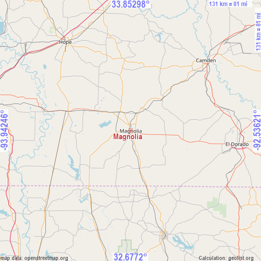
33° 16' 1.452" North, 93° 14' 21.588" West
| Map corner | latitude | longitude |
|---|---|---|
| Upper-left | 33.85298°, | -93.94246° |
| Center: | 33.26707°, | -93.23933° |
| Lower-right: | 32.6772°, | -92.53621° |
| Map W x H: | 130.7×130.7 km | = 81.2×81.2mi |
| max Lat: | 71.29058° ⇑84.1% North |
| Magnolia: | 33.26707° |
| min Lat: | ⇓15.9% South 19.06759° |
| min Long | Magnolia | max Long |
| -171.73463° | -93.23933° | -66.98998° |
| W 33.2%⇐ | ⇒66.8% E |
Elevation
Elevation of Magnolia is 106 m = 348 ft, and this is 188.8 m = 619 ft below average elevation for this country.
| Max E: |
3189 m = 10463 ft | 69.1% |
| Avg. | 294.8 m = 967 ft | |
| Magnolia | 106 m = 348 ft | |
Min E: |
-60 m = -197 ft | 30.9% |
See also: United States elevation on elevation.city.
Geographical zone
Magnolia is located in North temperate zone (between Tropic of Cancer and the Arctic Circle). Distance of this Northern Tropic circle is 1093 km =679.2 mi to South.| Distance of | km | miles | from Magnolia |
|---|---|---|---|
| North Pole | 6308.1 | 3919.7 | to North |
| Arctic Circle | 3702.2 | 2300.4 | to North |
| Tropic Cancer | 1093 | 679.2 | to South |
| Equator | 3699 | 2298.5 | to South |


Nearby cities:
15 places around Magnolia: (largest is in red/bold)
• Bradley
43 km =26.7 mi,  244°
244°
• Camden
51.6 km =32.1 mi,  46°
46°
• Cotton Valley
52.5 km =32.6 mi,  198°
198°
• Cullen
38.5 km =23.9 mi,  210°
210°
• El Dorado
53.7 km =33.4 mi,  97°
97°
• Haynesville
35.1 km =21.8 mi,  164°
164°
• Lewisville
33 km =20.5 mi,  287°
287°
• Norphlet
53.8 km =33.4 mi,  84°
84°
• Sarepta
45.9 km =28.5 mi, 205°
• Smackover
49 km =30.4 mi, 77°
• Springhill
35.9 km =22.3 mi,  216°
216°
• Stamps
26.2 km =16.3 mi, 294°
• Stephens
22.5 km =14 mi,  44°
44°
• Taylor
27.7 km =17.2 mi,  228°
228°
• Waldo
10.8 km =6.7 mi,  330°
330°
Sources, notices
• [Note1] Compared only with cities in United States existing in our database
• [Src1] Map data: © OpenStreetMap contributors (CC-BY-SA)
• [Src2] Other city data from geonames.org with taken over terms of usage.
• [Src3] Geographical zone / Annual Mean Temperature by Robert A. Rohde @ Wikipedia
