Sarepta geodata
Sarepta (Louisiana) is a populated place; located in United States in America/Chicago (GMT-5) time zone. With population of 864 people, there are 17246 cities with bigger population in this country. Compared to other cities in United States, 85.6% of cities are located further ↑North; 67.4% of cities are located further →East and 73.7% of cities have higher elevation than Sarepta. Note1


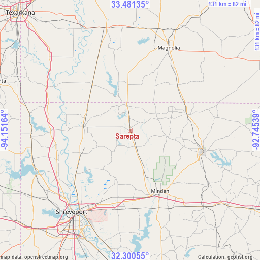
Sarepta GPS coordinates[2]
32° 53' 34.512" North, 93° 26' 54.636" West
| Map corner | latitude | longitude |
|---|---|---|
| Upper-left | 33.48135°, | -94.15164° |
| Center: | 32.89292°, | -93.44851° |
| Lower-right: | 32.30055°, | -92.74539° |
| Map W x H: | 131.3×131.3 km | = 81.6×81.6mi |
| max Lat: | 71.29058° ⇑85.6% North |
| Sarepta: | 32.89292° |
| min Lat: | ⇓14.4% South 19.06759° |
| min Long | Sarepta | max Long |
| -171.73463° | -93.44851° | -66.98998° |
| W 32.6%⇐ | ⇒67.4% E |
Elevation
Elevation of Sarepta is 79 m = 259 ft, and this is 215.8 m = 708 ft below average elevation for this country.
| Max E: |
3189 m = 10463 ft | 73.7% |
| Avg. | 294.8 m = 967 ft | |
| Sarepta | 79 m = 259 ft | |
Min E: |
-60 m = -197 ft | 26.3% |
See also: United States elevation on elevation.city.
Geographical zone
Sarepta is located in North temperate zone (between Tropic of Cancer and the Arctic Circle). Distance of this Northern Tropic circle is 1051.4 km =653.3 mi to South.| Distance of | km | miles | from Sarepta |
|---|---|---|---|
| North Pole | 6349.7 | 3945.5 | to North |
| Arctic Circle | 3743.8 | 2326.3 | to North |
| Tropic Cancer | 1051.4 | 653.3 | to South |
| Equator | 3657.3 | 2272.5 | to South |


Nearby cities:
15 places around Sarepta: (largest is in red/bold)
• Benton
35.2 km =21.9 mi,  231°
231°
• Bradley
29.9 km =18.6 mi,  319°
319°
• Cotton Valley
8.7 km =5.4 mi,  160°
160°
• Cullen
8.5 km =5.3 mi,  358°
358°
• Doyline
39.9 km =24.8 mi,  174°
174°
• Eastwood
39 km =24.2 mi,  196°
196°
• Haughton
40.4 km =25.1 mi,  187°
187°
• Haynesville
29.8 km =18.5 mi,  75°
75°
• Homer
38.4 km =23.9 mi,  106°
106°
• Minden
34.4 km =21.4 mi,  153°
153°
• Plain Dealing
23.2 km =14.4 mi,  273°
273°
• Red Chute
40.5 km =25.2 mi, 202°
• Sibley
41.8 km =26 mi, 160°
• Springhill
12.7 km =7.9 mi,  352°
352°
• Taylor
23.1 km =14.4 mi, 357°
Sources, notices
• [Note1] Compared only with cities in United States existing in our database
• [Src1] Map data: © OpenStreetMap contributors (CC-BY-SA)
• [Src2] Other city data from geonames.org with taken over terms of usage.
• [Src3] Geographical zone / Annual Mean Temperature by Robert A. Rohde @ Wikipedia
